IMAGES TAKEN NEAR TO
Clay Pit Grove, CHELTENHAM, GL51 8PU
Introduction
This page details the photographs taken nearby to Clay Pit Grove, GL51 8PU by members of the Geograph project.
The Geograph project started in 2005 with the aim of publishing, organising and preserving representative images for every square kilometre of Great Britain, Ireland and the Isle of Man.

There are currently over 7.5m images from over14,400 individuals and you can help contribute to the project by visiting https://www.geograph.org.uk
Image Map (Loading...)


Getting Data...Please wait
Leaflet Map data © OpenStreetMap
Images are licensed for reuse under creativecommons.org/licenses/by-sa/2.0
Notes
- Clicking on the map will re-center to the selected point.
- The higher the marker number, the further away the image location is from the centre of the postcode.
Image Listing (118 Images Found)
Images are licensed for reuse under creativecommons.org/licenses/by-sa/2.0
Image
Details
Distance
1
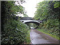
Former railway line in Cheltenham
On the approach to Malvern Road bridge.
Image: © Gareth James
Taken: 25 Sep 2017
0.03 miles
2
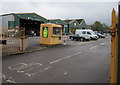
Entrance to Travis Perkins, Cheltenham
From Gloucester Road. This is one of more than 600 branches of Travis Perkins builders merchants in the UK.
Image: © Jaggery
Taken: 15 Apr 2016
0.05 miles
3
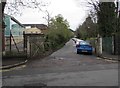
Side road to a recycling site, Cheltenham
From Malvern Road past the edge of Cheltenham Ladies College.
Image: © Jaggery
Taken: 15 Apr 2016
0.05 miles
4
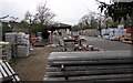
Travis Perkins yard on a Cheltenham corner
On the corner of Malvern Road and Gloucester Road, viewed over the perimeter railings.
Image: © Jaggery
Taken: 15 Apr 2016
0.05 miles
5
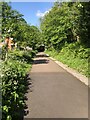
Pedestrian route on former railway
Utilising the former alignment of the Honeybourne line, a traffic free route has been created from Cheltenham Spa railway station to the town centre.
Image: © David Robinson
Taken: 15 May 2023
0.05 miles
6

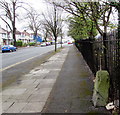
Old Milestone by the B4633, Gloucester Road, Cheltenham
Stone post (plate lost) by the B4633 (former A40), in parish of CHELTENHAM (CHELTENHAM District), Gloucester Road, 50m North of entrance to builders' yard, against railing - in Jan 2016 Amey proposed to move 3m back for bus-lane, on Southeast side of road. Erected by the Cheltenham & Gloucester turnpike trust in the 19th century.
Inscription once read:-
(Cheltenham)
(1)
Carved benchmark and rivet on top.
Milestone Society National ID: GL_CMGL01.
Image: © M Faherty
Taken: 13 Mar 2011
0.05 miles
7
Old milestone, Gloucester Road, Cheltenham
Alongside the B4633 Gloucester Road 70 metres from the Malvern Road junction (ahead).
Many decades (perhaps centuries) of weathering have obliterated the information inscribed on the stone.
Image: © Jaggery
Taken: 15 Apr 2016
0.06 miles
8
Warning sign - school, Malvern Road, Cheltenham
On the approach to Christ Church Primary School. http://www.geograph.org.uk/photo/5098798
Image: © Jaggery
Taken: 15 Apr 2016
0.06 miles
9
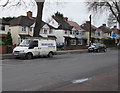
Hancocks van, Gloucester Road, Cheltenham
Based in Bishop's Cleeve near Cheltenham, Hancocks are bricklaying and repointing specialists.
Image: © Jaggery
Taken: 15 Apr 2016
0.06 miles
10
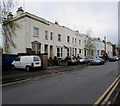
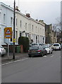
Malvern Road houses, Cheltenham
Viewed from near the corner of Gloucester Road.
Image: © Jaggery
Taken: 15 Apr 2016
0.06 miles