IMAGES TAKEN NEAR TO
St. Georges Close, CHELTENHAM, GL51 8PP
Introduction
This page details the photographs taken nearby to St. Georges Close, GL51 8PP by members of the Geograph project.
The Geograph project started in 2005 with the aim of publishing, organising and preserving representative images for every square kilometre of Great Britain, Ireland and the Isle of Man.

There are currently over 7.5m images from over14,400 individuals and you can help contribute to the project by visiting https://www.geograph.org.uk
Image Map (Loading...)


Getting Data...Please wait
Leaflet Map data © OpenStreetMap
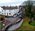
Images are licensed for reuse under creativecommons.org/licenses/by-sa/2.0
Notes
- Clicking on the map will re-center to the selected point.
- The higher the marker number, the further away the image location is from the centre of the postcode.
Image Listing (142 Images Found)
Images are licensed for reuse under creativecommons.org/licenses/by-sa/2.0
Image
Details
Distance
1
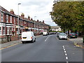
Houses and cars on Gloucester Road, looking north
Image: © Rob Purvis
Taken: 23 Sep 2019
0.03 miles
2
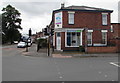
Smart Lettings in Cheltenham
Office at 29 Gloucester Road, on the corner of Arle Road.
Image: © Jaggery
Taken: 3 Aug 2016
0.06 miles
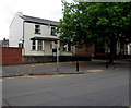
3
Arle Road, Cheltenham
From the corner of Gloucester Road.
Image: © Jaggery
Taken: 3 Aug 2016
0.07 miles
4
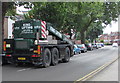
King Lifting vehicle in Gloucester Road, Cheltenham
King Lifting's head office is in Bristol at 1 Rockingham Park, Smoke Lane, Avonmouth.
Image: © Jaggery
Taken: 3 Aug 2016
0.08 miles
5
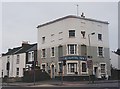
The Calcutta Inn
The Calcutta didn't exactly attract the best clientèle in its final days as a public house, but it was a landmark on Gloucester Road with its unique appearance. It was replaced by an unsympathetic housing development.
Image: © Helen Iwanczuk
Taken: Unknown
0.09 miles
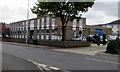
6
Cheltenham Orthodontics, Cheltenham
Located in Albion House, 58 Gloucester Road.
Image: © Jaggery
Taken: 3 Aug 2016
0.09 miles
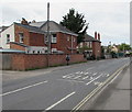
7
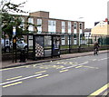
TA Centre bus stop and shelter, Cheltenham
The Arle Road bus stop is alongside a TA (Territorial Army) Centre.
Image: © Jaggery
Taken: 3 Aug 2016
0.09 miles
8
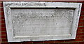
Weathered plaque on a Scholars Court wall, Cheltenham
Located on the left here, http://www.geograph.org.uk/photo/5140620 viewed in August 2016, when this plaque has undergone nearly a century of weathering. It records the opening of the Central School for Advanced Instruction in December 1919 and the enlargement of the school in 1920.
Image: © Jaggery
Taken: 3 Aug 2016
0.10 miles
9
Millbrook Street Cheltenham
Viewed from this http://www.geograph.org.uk/photo/3510592 bridge. Millbrook Street is ahead, Great Western Terrace is on the left.
Image: © Jaggery
Taken: 25 Nov 2011
0.11 miles
10
TA Centre, Cheltenham
Territorial Army Centre viewed across Arle Road from the corner of Arle Avenue.
Image: © Jaggery
Taken: 3 Aug 2016
0.11 miles