IMAGES TAKEN NEAR TO
Arle Avenue, CHELTENHAM, GL51 8LE
Introduction
This page details the photographs taken nearby to Arle Avenue, GL51 8LE by members of the Geograph project.
The Geograph project started in 2005 with the aim of publishing, organising and preserving representative images for every square kilometre of Great Britain, Ireland and the Isle of Man.

There are currently over 7.5m images from over14,400 individuals and you can help contribute to the project by visiting https://www.geograph.org.uk
Image Map
Images are licensed for reuse under creativecommons.org/licenses/by-sa/2.0
Notes
- Clicking on the map will re-center to the selected point.
- The higher the marker number, the further away the image location is from the centre of the postcode.
Image Listing (101 Images Found)
Images are licensed for reuse under creativecommons.org/licenses/by-sa/2.0
Image
Details
Distance
1
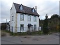
Alstone House
An interesting and clearly older house in this part of Cheltenham. The house is Grade II listed https://historicengland.org.uk/listing/the-list/list-entry/1386688 and thought partly to originate from the late 17th century with later additions. The house is located near the River Chelt.
Image: © Philip Halling
Taken: 12 Mar 2020
0.02 miles
2
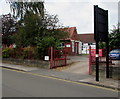
Entrance to Gloucester Road School, Cheltenham
This entrance from the B4633 Gloucester Road is for school staff and authorised visitors only.
Image: © Jaggery
Taken: 3 Aug 2016
0.06 miles
3
Gloucester Road School, Cheltenham
Primary & nursery school at 54 Gloucester Road.
Image: © Jaggery
Taken: 3 Aug 2016
0.07 miles
4
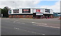
DW Sports Store, Cheltenham
Located in the Roundhouse, a 50 metre diameter circular building at 19 Gloucester Road, viewed in August 2016. A May 2009 Google Earth Street View shows JJB Sports Superstore in the Roundhouse.
Image: © Jaggery
Taken: 3 Aug 2016
0.07 miles
5
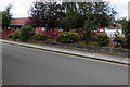
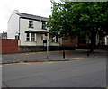
Scholars Court, Cheltenham
Modern cul-de-sac on the site of the former Central School for Advanced Instruction which opened in 1919.
http://www.geograph.org.uk/photo/5140678 to a closer view of the plaque on the left.
Image: © Jaggery
Taken: 3 Aug 2016
0.07 miles
6
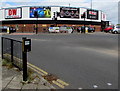
DW Sports Store, Cheltenham
Located in the Roundhouse, a 50 metre diameter circular building at 19 Gloucester Road, viewed in August 2016. A May 2009 Google Earth Street View shows JJB Sports Superstore in the Roundhouse.
Image: © Jaggery
Taken: 3 Aug 2016
0.08 miles
7

Spa Service, 2 Lower Mill Street, Cheltenham
Domestic appliance centre set back from Gloucester Road.
Image: © Jaggery
Taken: 3 Aug 2016
0.08 miles
8
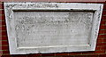
Weathered plaque on a Scholars Court wall, Cheltenham
Located on the left here, http://www.geograph.org.uk/photo/5140620 viewed in August 2016, when this plaque has undergone nearly a century of weathering. It records the opening of the Central School for Advanced Instruction in December 1919 and the enlargement of the school in 1920.
Image: © Jaggery
Taken: 3 Aug 2016
0.09 miles
9
Cheltenham Orthodontics, Cheltenham
Located in Albion House, 58 Gloucester Road.
Image: © Jaggery
Taken: 3 Aug 2016
0.10 miles
10
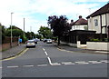
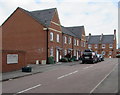
Arle Avenue, Cheltenham
On the northeast side of Arle Road.
Image: © Jaggery
Taken: 3 Aug 2016
0.10 miles