IMAGES TAKEN NEAR TO
Princess Elizabeth Way, CHELTENHAM, GL51 7SJ
Introduction
This page details the photographs taken nearby to Princess Elizabeth Way, GL51 7SJ by members of the Geograph project.
The Geograph project started in 2005 with the aim of publishing, organising and preserving representative images for every square kilometre of Great Britain, Ireland and the Isle of Man.

There are currently over 7.5m images from over14,400 individuals and you can help contribute to the project by visiting https://www.geograph.org.uk
Image Map (Loading...)


Getting Data...Please wait
Leaflet Map data © OpenStreetMap
Images are licensed for reuse under creativecommons.org/licenses/by-sa/2.0
Notes
- Clicking on the map will re-center to the selected point.
- The higher the marker number, the further away the image location is from the centre of the postcode.
Image Listing (24 Images Found)
Images are licensed for reuse under creativecommons.org/licenses/by-sa/2.0
Image
Details
Distance
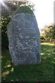
1
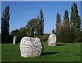
The Listening Stones
By Gordon Young who worked with children from Monkscroft Primary School, sixth-formers from Cleeve School, GCHQ staff, local residents and staff on the local paper, looking for ideas for the text, markings and symbols which cover the stones.
Image: © Bob Embleton
Taken: 19 Oct 2007
0.07 miles
2
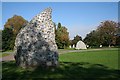
The Listening Stones
Sculptured by Gordon Young and placed in Hester's Way Park. The commission was made possible by a £75,000 contribution to public art in Cheltenham by IAP, the company responsible for constructing the new GCHQ
Image: © Bob Embleton
Taken: 19 Oct 2007
0.07 miles
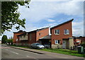
3
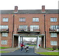
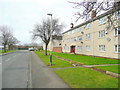
Hobart House
Post-WW2 housing on Princess Elizabeth Way, St.Mark's, Cheltenham.
Image: © Jonathan Billinger
Taken: 8 Feb 2010
0.09 miles
5
One of the Listening Stones in Hester's Way Park
Sculptured by Gordon Young. Featured on the stones are encrypted messages, words and puzzles inspired by the work of GCHQ, text messaging, newspaper headlines and the first words children learn to read at school.
Image: © Bob Embleton
Taken: 19 Oct 2007
0.14 miles
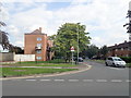
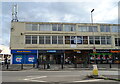
6
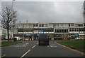
Shopping parade on Princess Elizabeth Way
The row of shops forms one side of a rather unusual roundabout arrangement where the main road meets Marsland Road and Edinburgh Place.
Image: © Peter Whatley
Taken: 22 Nov 2012
0.14 miles
9
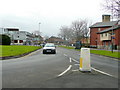
Older social housing, Hester's Way, Cheltenham 2
Marsland Road, looking west.
Image: © Jonathan Billinger
Taken: 6 Feb 2011
0.16 miles
10
Coronation Square, Hester's Way, Cheltenham
A suburb of Cheltenham dating to the 1950's.
The modernist bell tower of St. Aidan's church appears far right.
Image: © Jonathan Billinger
Taken: 6 Feb 2011
0.16 miles