IMAGES TAKEN NEAR TO
Orchard Avenue, CHELTENHAM, GL51 7ND
Introduction
This page details the photographs taken nearby to Orchard Avenue, GL51 7ND by members of the Geograph project.
The Geograph project started in 2005 with the aim of publishing, organising and preserving representative images for every square kilometre of Great Britain, Ireland and the Isle of Man.

There are currently over 7.5m images from over14,400 individuals and you can help contribute to the project by visiting https://www.geograph.org.uk
Image Map
Images are licensed for reuse under creativecommons.org/licenses/by-sa/2.0
Notes
- Clicking on the map will re-center to the selected point.
- The higher the marker number, the further away the image location is from the centre of the postcode.
Image Listing (19 Images Found)
Images are licensed for reuse under creativecommons.org/licenses/by-sa/2.0
Image
Details
Distance
1
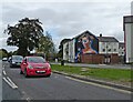
Block of flats with mural, on Princess Elizabeth Way
Image: © Roger Cornfoot
Taken: 27 Sep 2022
0.12 miles
2
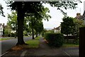
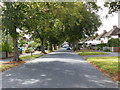
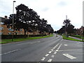
Brooklyn Road, Cheltenham
Heading towards Orchard Way, on the western side of Cheltenham
Image: © Chris Heaton
Taken: 31 Jul 2023
0.12 miles
3
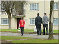
Sunday pop to the shop
Folks walking north along Princess Elizabeth Way, Cheltenham.
Image: © Jonathan Billinger
Taken: 6 Feb 2011
0.13 miles
4
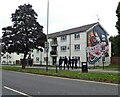
Block of flats with mural, on Princess Elizabeth Way
Image: © Roger Cornfoot
Taken: 27 Sep 2022
0.15 miles
10
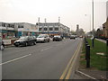
Edinburgh Place
Edinburgh Place approaching Coronation Square in the Hester's Way area of Cheltenham.
Image: © Philip Halling
Taken: 26 Mar 2011
0.23 miles