IMAGES TAKEN NEAR TO
Nettleton Road, CHELTENHAM, GL51 6NR
Introduction
This page details the photographs taken nearby to Nettleton Road, GL51 6NR by members of the Geograph project.
The Geograph project started in 2005 with the aim of publishing, organising and preserving representative images for every square kilometre of Great Britain, Ireland and the Isle of Man.

There are currently over 7.5m images from over14,400 individuals and you can help contribute to the project by visiting https://www.geograph.org.uk
Image Map (Loading...)


Getting Data...Please wait
Leaflet Map data © OpenStreetMap
Images are licensed for reuse under creativecommons.org/licenses/by-sa/2.0
Notes
- Clicking on the map will re-center to the selected point.
- The higher the marker number, the further away the image location is from the centre of the postcode.
Image Listing (70 Images Found)
Images are licensed for reuse under creativecommons.org/licenses/by-sa/2.0
Image
Details
Distance
1
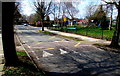
Zigzag markings and speed bump on Robert Burns Avenue, Cheltenham
Marking a Keep Clear Zone on the approach to Benhall Infant School and Pre-School.
Image: © Jaggery
Taken: 3 Apr 2016
0.07 miles
2
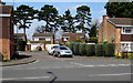
Hatherley Brake, Cheltenham
Cul-de-sac on the north side of Hatherley Road.
Image: © Jaggery
Taken: 3 Apr 2016
0.07 miles
3

Benhall Infant School and Pre-School name sign, Cheltenham
On the right here. http://www.geograph.org.uk/photo/5100840
Image: © Jaggery
Taken: 3 Apr 2016
0.08 miles
4
Robert Burns Avenue electricity substation, Cheltenham
Located at a school perimeter fence, the Western Power Distribution electricity substation number is 1455.
A caution notice shows the presence of SF6 (sulphur hexafluoride, an insulating gas used in high voltage systems).
Image: © Jaggery
Taken: 3 Apr 2016
0.08 miles
5
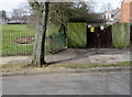
School entrance from Robert Burns Avenue, Cheltenham
Into Benhall Infant School and Pre-School. http://www.geograph.org.uk/photo/5100847 to the name sign.
Image: © Jaggery
Taken: 3 Apr 2016
0.08 miles
6
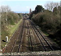
The Down Goods Loop at Hatherley
The Down Goods Loop is the line on the right.
Image: © Steve Daniels
Taken: 2 Sep 2009
0.08 miles
7
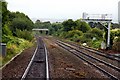
Railway from Hatherley Bridge towards Cheltenham Spa railway station
Viewed from this http://www.geograph.org.uk/photo/510099 bridge. Cheltenham Spa railway station is about a mile (c1.6 km) ahead.
Image: © Jaggery
Taken: 3 Apr 2016
0.09 miles
8
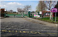
Towards Benhall Infant School and Pre-School, Cheltenham
Viewed from Robert Burns Avenue.
Image: © Jaggery
Taken: 3 Apr 2016
0.09 miles
9
NO DOGS ALLOWED notice facing Robert Burns Avenue, Cheltenham
Alongside a path into Benhall Infant School.
Image: © Jaggery
Taken: 3 Apr 2016
0.09 miles
10
Patrol warning sign facing Robert Burns Avenue, Cheltenham
Opposite the Colesbourne Road junction http://www.geograph.org.uk/photo/5002659 on the approach to schools.
Image: © Jaggery
Taken: 3 Apr 2016
0.09 miles