1
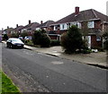
Houses on Gloucester Road (A40), Cheltenham
Image: © JThomas
Taken: 9 Aug 2021
0.10 miles
2
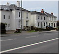
Campden Road houses, Cheltenham
The houses face trees and hedges on the south side of the A40 Gloucester Road.
Image: © Jaggery
Taken: 3 Apr 2016
0.11 miles
3
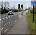
Cycle route and footpath viewed across Gloucester Road, Cheltenham
The combined cycle route and footpath ahead is along Campden Road, a quieter route parallel with the A40 Gloucester Road. A nearby cycle route signpost pointing this way shows 3 minutes to Benhall, 40 minutes to Gloucester. These are the times taken by the "average cyclist" - defined as you will. Multiply the times by 3 or 4 for the "average walker" and by 5 or 6 if the walker is this contributor with a camera...
Image: © Jaggery
Taken: 3 Apr 2016
0.11 miles
4
Gloucester Road houses, Cheltenham
On the south side of the A40 Gloucester Road, west of Granley Road.
Image: © Jaggery
Taken: 3 Apr 2016
0.11 miles
5
Gloucester Road houses, Cheltenham
On the south side of the A40 Gloucester Road.
Image: © Jaggery
Taken: 3 Apr 2016
0.11 miles
6
Pelican crossing, Gloucester Road, Cheltenham
Across the A40 Gloucester Road between Kingsley Gardens and Campden Road.
Chambers Dictionary states that pelican in this context is adapted from "pedestrian light controlled crossing".
Image: © Jaggery
Taken: 3 Apr 2016
0.11 miles
7
Notgrove Close
Road in the suburbs of Cheltenham.
Image: © Wayland Smith
Taken: 17 Apr 2021
0.11 miles
8
Kingsley Gardens
Viewed from the A40
Image: © Clint Mann
Taken: 1 Apr 2016
0.12 miles
9
Cycle route directions signs, Gloucester Road, Cheltenham
On the north side of the A40 Gloucester Road. Ahead for Hester's Way or use the pelican crossing to the south side of Gloucester Road for this http://www.geograph.org.uk/photo/5035723 cycle route towards Benhall and Gloucester.
Image: © Jaggery
Taken: 3 Apr 2016
0.12 miles
10
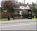
Gloucester Road bus stop and shelter, Cheltenham
This side of the road for buses towards Cheltenham town centre.
Image: © Jaggery
Taken: 3 Apr 2016
0.13 miles


