IMAGES TAKEN NEAR TO
Cold Pool Lane, CHELTENHAM, GL51 4UP
Introduction
This page details the photographs taken nearby to Cold Pool Lane, GL51 4UP by members of the Geograph project.
The Geograph project started in 2005 with the aim of publishing, organising and preserving representative images for every square kilometre of Great Britain, Ireland and the Isle of Man.

There are currently over 7.5m images from over14,400 individuals and you can help contribute to the project by visiting https://www.geograph.org.uk
Image Map (Loading...)


Getting Data...Please wait
Leaflet Map data © OpenStreetMap
Images are licensed for reuse under creativecommons.org/licenses/by-sa/2.0
Notes
- Clicking on the map will re-center to the selected point.
- The higher the marker number, the further away the image location is from the centre of the postcode.
Image Listing (3 Images Found)
Images are licensed for reuse under creativecommons.org/licenses/by-sa/2.0
Image
Details
Distance
1
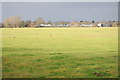
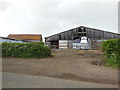
Farmland near Badgeworth
Farmland and farm buildings near Badgeworth.
Image: © Philip Halling
Taken: 21 Jan 2012
0.08 miles
3
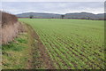
Arable land near Badgeworth
A footpath follows the hedgerow on the left of this field, it has been adopted by a walk called the Cheltenham Circular Footpath, which as it says on the tin, circumnavigates Cheltenham. Leckhampton Hill and Shurdington Hill can be seen in the background.
Image: © Philip Halling
Taken: 21 Jan 2012
0.17 miles