IMAGES TAKEN NEAR TO
Church Lane, CHELTENHAM, GL51 4TQ
Introduction
This page details the photographs taken nearby to Church Lane, GL51 4TQ by members of the Geograph project.
The Geograph project started in 2005 with the aim of publishing, organising and preserving representative images for every square kilometre of Great Britain, Ireland and the Isle of Man.

There are currently over 7.5m images from over14,400 individuals and you can help contribute to the project by visiting https://www.geograph.org.uk
Image Map
Images are licensed for reuse under creativecommons.org/licenses/by-sa/2.0
Notes
- Clicking on the map will re-center to the selected point.
- The higher the marker number, the further away the image location is from the centre of the postcode.
Image Listing (77 Images Found)
Images are licensed for reuse under creativecommons.org/licenses/by-sa/2.0
Image
Details
Distance
1
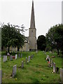
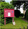
St Paul's Church and churchyard, Shurdington
In the Church of England Diocese of Gloucester.
The building which has early 14th century origins was restored
and extended in 1852. Grade II (star) listed in 1960.
Image: © Jaggery
Taken: 23 Jun 2019
0.02 miles
2
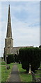
Parish Church of St Paul, Shurdington
In the Church of England Diocese of Gloucester.
The building which has early 14th century
origins was restored and extended in 1852.
Grade II (star) listed in 1960.
Image: © Jaggery
Taken: 23 Jun 2019
0.02 miles
3
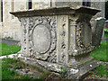
Monument, Shurdington
An ornate early C19th chest tomb, occupant(s) unidentifed. Grade II listed.
Image: © Stephen Richards
Taken: 21 Aug 2015
0.03 miles
4
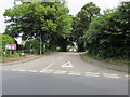
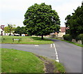
School Lane, Shurdington
From Church Lane, School Lane leads to the cul-de-sac Blenheim Orchard.
Image: © Jaggery
Taken: 23 Jun 2019
0.03 miles
5
Information board, St Paul's Church, Shurdington
In June 2019 an information sheet partially covers outdated information on the board located here. https://www.geograph.org.uk/photo/6193610
Image: © Jaggery
Taken: 23 Jun 2019
0.03 miles
6
Junction of Bishop Road and Church Lane, Shurdington
Bishop Road from the left joins Church Lane.
Image: © Jaggery
Taken: 23 Jun 2019
0.03 miles
7
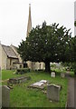
Yew in St Paul's churchyard, Shurdington
The European Yew (Taxus baccata) is an evergreen tree often found
in churchyards in the UK, Ireland, France and northern parts of Spain.
Image: © Jaggery
Taken: 23 Jun 2019
0.03 miles
8
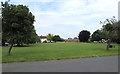
Village Green, Shurdington
Viewed across Bishop Road from the corner of Mitre Gardens.
Image: © Jaggery
Taken: 23 Jun 2019
0.04 miles
9
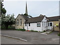
Shurdington Church Hall
The hall alongside School Lane is located northeast of St Paul's Church.
The church spire https://www.geograph.org.uk/photo/6193603 is in the background.
Image: © Jaggery
Taken: 23 Jun 2019
0.04 miles
10
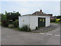
Blenheim Orchard electricity substation, Shurdington
The Western Power Distribution electricity substation is on the corner of
School Lane and Blenheim Orchard. Its identifier is BLENHEIM ORCHARD 1264.
Image: © Jaggery
Taken: 23 Jun 2019
0.05 miles