1
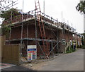
House construction, School Lane, Shurdington
A house is being built in June 2019.
Image: © Jaggery
Taken: 23 Jun 2019
0.01 miles
2
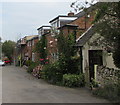
Blenheim Cottages, School Lane, Shurdington
On the east side of School Lane near its northern end.
Image: © Jaggery
Taken: 23 Jun 2019
0.01 miles
3
On-street parking, School Lane, Shurdington
This is the dead-end part of School Lane, north of the Blenheim Orchard junction.
Image: © Jaggery
Taken: 23 Jun 2019
0.01 miles
4
Shurdington Church Hall
The hall alongside School Lane is located northeast of St Paul's Church.
The church spire https://www.geograph.org.uk/photo/6193603 is in the background.
Image: © Jaggery
Taken: 23 Jun 2019
0.03 miles
5
Blenheim Orchard electricity substation, Shurdington
The Western Power Distribution electricity substation is on the corner of
School Lane and Blenheim Orchard. Its identifier is BLENHEIM ORCHARD 1264.
Image: © Jaggery
Taken: 23 Jun 2019
0.03 miles
6
Yew in St Paul's churchyard, Shurdington
The European Yew (Taxus baccata) is an evergreen tree often found
in churchyards in the UK, Ireland, France and northern parts of Spain.
Image: © Jaggery
Taken: 23 Jun 2019
0.04 miles
7
Northern end of School Lane, Shurdington
School Lane ends near Ham Brook.
Image: © Jaggery
Taken: 23 Jun 2019
0.04 miles
8
Shurdington church
Shurdington church is dedicated to St Paul.
Image: © Philip Halling
Taken: 29 Jan 2011
0.05 miles
9
Monument, Shurdington
An ornate early C19th chest tomb, occupant(s) unidentifed. Grade II listed.
Image: © Stephen Richards
Taken: 21 Aug 2015
0.05 miles
10
St Paul's Church and churchyard, Shurdington
In the Church of England Diocese of Gloucester.
The building which has early 14th century origins was restored
and extended in 1852. Grade II (star) listed in 1960.
Image: © Jaggery
Taken: 23 Jun 2019
0.05 miles


