
IMAGES TAKEN NEAR TO
Greatfield Lane, CHELTENHAM, GL51 3QQ
Introduction
This page details the photographs taken nearby to Greatfield Lane, GL51 3QQ by members of the Geograph project.
The Geograph project started in 2005 with the aim of publishing, organising and preserving representative images for every square kilometre of Great Britain, Ireland and the Isle of Man.

There are currently over 7.5m images from over14,400 individuals and you can help contribute to the project by visiting https://www.geograph.org.uk
Image Map
Images are licensed for reuse under creativecommons.org/licenses/by-sa/2.0
Notes
- Clicking on the map will re-center to the selected point.
- The higher the marker number, the further away the image location is from the centre of the postcode.
Image Listing (7 Images Found)
Images are licensed for reuse under creativecommons.org/licenses/by-sa/2.0
Image
Details
Distance
1
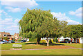
Mynd Green
Long Mynd Avenue in Cheltenham.
Image: © Wayland Smith
Taken: 22 Sep 2021
0.11 miles
3
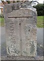
Old Boundary Marker on Hatherley Road, Up Hatherley
Municipal Boundary Marker set in the outer edge of the pavement on the east side of the T junction of Hatherley Road and Coombe Glen Lane. Was on the boundary of Cheltenham and Up Hatherley parishes but now entirely in Up Hatherley parish. Inscribed CHELTENHAM and G. C. C. on adjacent faces and B. OF C. / 1935 above both. See also https://www.geograph.org.uk/photo/7089396.
Milestone Society National ID: GL_CMGL04pb
Image: © D Young
Taken: 23 Mar 2016
0.21 miles
4
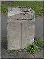
Old Boundary Marker on Hatherley Road, Up Hatherley
Municipal Boundary Marker set in the outer edge of the pavement on the east side of the T junction of Hatherley Road and Coombe Glen Lane. Was on the boundary of Cheltenham and Up Hatherley parishes but now entirely in Up Hatherley parish. Inscribed CHELTENHAM and G. C. C. on adjacent faces and (B. OF C. now lost due to damage) / 1935 above both. See also https://www.geograph.org.uk/photo/6093867.
Milestone Society National ID: GL_CMGL04pb
Image: © Roadside Relics
Taken: 2 Feb 2022
0.21 miles
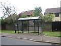
6
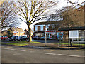
Bus stop near the shops, Up Hatherley
The shops are at the junction of Hatherley Road and Caernarvon Road, southwest Cheltenham.
Image: © Pauline E
Taken: 17 Dec 2008
0.22 miles
7
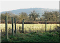
December day on Leckhampton Hill
Viewed from Chargrove Lane.
Image: © Pauline E
Taken: 17 Dec 2008
0.23 miles