IMAGES TAKEN NEAR TO
Alma Road, CHELTENHAM, GL51 3LT
Introduction
This page details the photographs taken nearby to Alma Road, GL51 3LT by members of the Geograph project.
The Geograph project started in 2005 with the aim of publishing, organising and preserving representative images for every square kilometre of Great Britain, Ireland and the Isle of Man.

There are currently over 7.5m images from over14,400 individuals and you can help contribute to the project by visiting https://www.geograph.org.uk
Image Map (Loading...)


Getting Data...Please wait
Leaflet Map data © OpenStreetMap
Images are licensed for reuse under creativecommons.org/licenses/by-sa/2.0
Notes
- Clicking on the map will re-center to the selected point.
- The higher the marker number, the further away the image location is from the centre of the postcode.
Image Listing (31 Images Found)
Images are licensed for reuse under creativecommons.org/licenses/by-sa/2.0
Image
Details
Distance
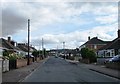
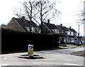
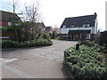
3
Alma Road, Cheltenham
Alma Road and the junction with Loweswater Road in Cheltenham.
Image: © Philip Halling
Taken: 13 Aug 2011
0.11 miles
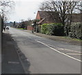
5
Hedge and houses, Alma Road, Cheltenham
Viewed from Hatherley Road.
Image: © Jaggery
Taken: 3 Apr 2016
0.12 miles
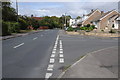
7
Alma Road, Cheltenham
Looking to the SW from Hatherley Road.
Image: © Jaggery
Taken: 3 Apr 2016
0.13 miles
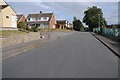
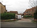
8
Manse Gardens, Cheltenham
Cul-de-sac on the south side of Hatherley Road.
Image: © Jaggery
Taken: 3 Apr 2016
0.14 miles
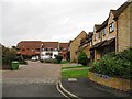
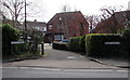
9
Deacon Close, Cheltenham
Cul-de-sac on the south side of Hatherley Road.
Image: © Jaggery
Taken: 3 Apr 2016
0.15 miles
10
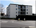
Four-storey block of flats, Alma Road, Cheltenham
Viewed from Hatherley Road.
Image: © Jaggery
Taken: 3 Apr 2016
0.17 miles