IMAGES TAKEN NEAR TO
Dinas Road, CHELTENHAM, GL51 3ER
Introduction
This page details the photographs taken nearby to Dinas Road, GL51 3ER by members of the Geograph project.
The Geograph project started in 2005 with the aim of publishing, organising and preserving representative images for every square kilometre of Great Britain, Ireland and the Isle of Man.

There are currently over 7.5m images from over14,400 individuals and you can help contribute to the project by visiting https://www.geograph.org.uk
Image Map (Loading...)


Getting Data...Please wait
Leaflet Map data © OpenStreetMap
Images are licensed for reuse under creativecommons.org/licenses/by-sa/2.0
Notes
- Clicking on the map will re-center to the selected point.
- The higher the marker number, the further away the image location is from the centre of the postcode.
Image Listing (2 Images Found)
Images are licensed for reuse under creativecommons.org/licenses/by-sa/2.0
Image
Details
Distance
2

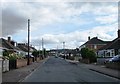
A glimpse of the past
The gradual expansion of the suburbs of Cheltenham has absorbed a number of once separate communities. Here at the cul-de-sac western end of Farmfield Road, between Up Hatherley and Warden Hill, a gateway provides access to a field which has so far escaped being built-over.
Image: © Richard Dorrell
Taken: 3 Mar 2013
0.23 miles