IMAGES TAKEN NEAR TO
Springbank Way, CHELTENHAM, GL51 0LQ
Introduction
This page details the photographs taken nearby to Springbank Way, GL51 0LQ by members of the Geograph project.
The Geograph project started in 2005 with the aim of publishing, organising and preserving representative images for every square kilometre of Great Britain, Ireland and the Isle of Man.

There are currently over 7.5m images from over14,400 individuals and you can help contribute to the project by visiting https://www.geograph.org.uk
Image Map
Images are licensed for reuse under creativecommons.org/licenses/by-sa/2.0
Notes
- Clicking on the map will re-center to the selected point.
- The higher the marker number, the further away the image location is from the centre of the postcode.
Image Listing (4 Images Found)
Images are licensed for reuse under creativecommons.org/licenses/by-sa/2.0
Image
Details
Distance
1
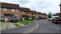
Somergate Road
A 1980's estate on the western fringe of Cheltenham.
Image: © Jonathan Billinger
Taken: 5 Jun 2012
0.10 miles
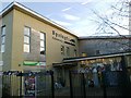
3
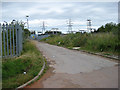
Sub-station, Springbank
Not a pleasant view from the houses across the road.
Image: © Pauline E
Taken: 12 Jul 2008
0.22 miles
4
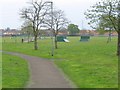
Springbank Park
A patch of green in the heart of the Hester's Way estate on the Northwestern edge of Cheltenham.
Image: © Stephen Bowden
Taken: 23 Apr 2005
0.24 miles