IMAGES TAKEN NEAR TO
Dorrington Walk, CHELTENHAM, GL51 0JE
Introduction
This page details the photographs taken nearby to Dorrington Walk, GL51 0JE by members of the Geograph project.
The Geograph project started in 2005 with the aim of publishing, organising and preserving representative images for every square kilometre of Great Britain, Ireland and the Isle of Man.

There are currently over 7.5m images from over14,400 individuals and you can help contribute to the project by visiting https://www.geograph.org.uk
Image Map
Images are licensed for reuse under creativecommons.org/licenses/by-sa/2.0
Notes
- Clicking on the map will re-center to the selected point.
- The higher the marker number, the further away the image location is from the centre of the postcode.
Image Listing (26 Images Found)
Images are licensed for reuse under creativecommons.org/licenses/by-sa/2.0
Image
Details
Distance
1
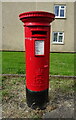
Elizabeth II postbox on Marsland Road, Cheltenham
Postbox No. GL51 313.
See Image] for context.
Image: © JThomas
Taken: 9 Aug 2021
0.04 miles
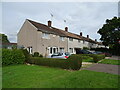
3
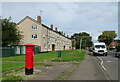
Houses on Marsland Road, Cheltenham
Showing position of Postbox No. GL51 313.
See Image] for postbox.
Image: © JThomas
Taken: 9 Aug 2021
0.04 miles
4
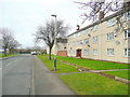
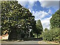
Older social housing, Hester's Way, Cheltenham 2
Marsland Road, looking west.
Image: © Jonathan Billinger
Taken: 6 Feb 2011
0.05 miles
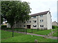
8
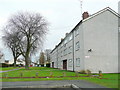
Older social housing, Hester's Way, Cheltenham 1
Flats by Marsland Road.
Image: © Jonathan Billinger
Taken: 6 Feb 2011
0.08 miles
9
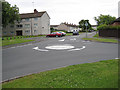
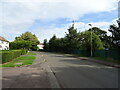
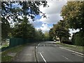
Roundabout, Fiddlers Green Lane
This area of Cheltenham is known as Fiddler's Green.
Image: © Pauline E
Taken: 12 Jul 2008
0.09 miles