IMAGES TAKEN NEAR TO
Distel Close, CHELTENHAM, GL50 4SN
Introduction
This page details the photographs taken nearby to Distel Close, GL50 4SN by members of the Geograph project.
The Geograph project started in 2005 with the aim of publishing, organising and preserving representative images for every square kilometre of Great Britain, Ireland and the Isle of Man.

There are currently over 7.5m images from over14,400 individuals and you can help contribute to the project by visiting https://www.geograph.org.uk
Image Map
Images are licensed for reuse under creativecommons.org/licenses/by-sa/2.0
Notes
- Clicking on the map will re-center to the selected point.
- The higher the marker number, the further away the image location is from the centre of the postcode.
Image Listing (14 Images Found)
Images are licensed for reuse under creativecommons.org/licenses/by-sa/2.0
Image
Details
Distance
1
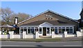
The Ridge
The former Haymaker pub, in Wyman's Brook.
Image: © Helen Iwanczuk
Taken: 4 Mar 2011
0.04 miles
2
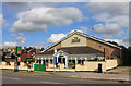
The Ridge
The Ridge in Wyman's Brook, was renovated in 2015.
Image: © Helen Iwanczuk
Taken: 1 Aug 2015
0.04 miles
3
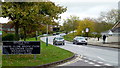
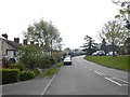
Windyridge Road
On the northern edge of Cheltenham in Wyman's Brook.
The brook itself runs under the road in the middle of this shot.
The pub across the road is The Ridge - a countrified name for an estate pub.
Image: © Jonathan Billinger
Taken: 1 Nov 2012
0.05 miles
4
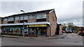
Wyman's Brook Pharmacy
A suburb on the northern side of Cheltenham.
Image: © Jonathan Billinger
Taken: 1 Nov 2012
0.08 miles
6
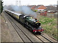
4965 Rood Ashton Hall Cheltenham
4965 Rood Ashton Hall approaching Cheltenham Spa hauling the "Red Dragon" excursion from Tyseley to Cardiff and return.
Image: © Roy Hughes
Taken: 7 Mar 2015
0.19 miles
7
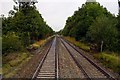
Bristol to Birmingham Railway, Swindon Lane Level Crossing View
Image: © Roy Hughes
Taken: 22 Dec 2014
0.21 miles
9
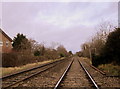
Tommy Taylor's Lane and Swindon Lane Junction Cheltenham
Image: © Roy Hughes
Taken: 29 Nov 2014
0.23 miles
10
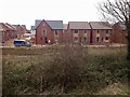
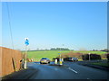
Swindon Lane - a residential road on the north of Cheltenham
The houses on the left mark the edge of the built-up area. They back onto farmland
Image: © David Smith
Taken: 7 May 2016
0.24 miles