IMAGES TAKEN NEAR TO
Marle Hill Parade, CHELTENHAM, GL50 4LG
Introduction
This page details the photographs taken nearby to Marle Hill Parade, GL50 4LG by members of the Geograph project.
The Geograph project started in 2005 with the aim of publishing, organising and preserving representative images for every square kilometre of Great Britain, Ireland and the Isle of Man.

There are currently over 7.5m images from over14,400 individuals and you can help contribute to the project by visiting https://www.geograph.org.uk
Image Map
Images are licensed for reuse under creativecommons.org/licenses/by-sa/2.0
Notes
- Clicking on the map will re-center to the selected point.
- The higher the marker number, the further away the image location is from the centre of the postcode.
Image Listing (138 Images Found)
Images are licensed for reuse under creativecommons.org/licenses/by-sa/2.0
Image
Details
Distance
1
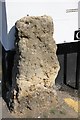
Stone block on the corner of Wellesley Road and Clarington Mews
The block obviously predates all the buildings around it. I cannot find anything explaining what it was part of and why it was left.
Image: © Terry Jacombs
Taken: 28 Mar 2012
0.03 miles
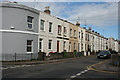
2
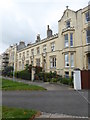
Terraced houses in Wellington Square West
Image: © Rod Allday
Taken: 28 Sep 2019
0.06 miles
3
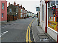
Marle Hill Parade, Cheltenham
At the right is a Chinese takeaway. Marle Hill Parade leads away from the viewpoint.
Image: © Brian Robert Marshall
Taken: 5 Nov 2009
0.06 miles
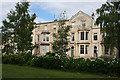
4
![Cheltenham houses [120]](https://s2.geograph.org.uk/geophotos/06/91/72/6917226_6ea87609_120x120.jpg)
Cheltenham houses [120]
This terrace of 12 houses, numbers 31 to 42 Clarence Square, were built in 1837. Constructed of stuccoed brick with fine detailing, slate roof and iron balconies, verandah and railings. The middle six houses are 3 storeys, the other six are 2 storeys. Clarence Square was named after the Duke of Clarence, who became William IV in 1830. Listed, grade II, with details at: https://historicengland.org.uk/listing/the-list/list-entry/1386851
Cheltenham is located at the foot of the Cotswold scarp with the small River Chelt flowing through the town. After the discovery of mineral springs in 1716 Cheltenham became a spa town and many Regency houses and other buildings were erected. The town is home to the renowned Cheltenham Festival, four days of horse jump racing culminating in the Gold Cup, held annually in March at the nearby racecourse.
Image: © Michael Dibb
Taken: 19 May 2021
0.08 miles
5
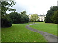
Clarence Square
S mall leafy square in the Georgian heart of Cheltenham.
Image: © Anne Burgess
Taken: 7 Jul 2014
0.09 miles
6
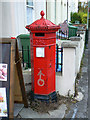
Penfold pillar box, St Paul's Road, Cheltenham
Here is one of the eight Penfold Victorian postboxes in the town. It looks rather neglected despite it being listed http://www.imagesofengland.org.uk/details/default.aspx?id=475899 It is situated outside a Chinese takeaway. It can be seen in its context here Image
Image: © Brian Robert Marshall
Taken: 5 Nov 2009
0.09 miles
8
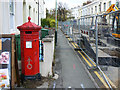
Penfold pillar box and St Paul's Road, Cheltenham
St Paul's Road is closed to traffic for the time being. Holes have been dug in it. At the left is the Victorian postbox seen in more detail here Image
Image: © Brian Robert Marshall
Taken: 5 Nov 2009
0.09 miles
9
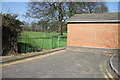
Wellesley Road entrance to Agg Gardner recreation ground
One of several entrances to the recreation ground from the network of roads on its southern edge.
Image: © Terry Jacombs
Taken: 28 Mar 2012
0.10 miles
10
Georgian Houses
The houses here are Georgian, but much plainer than some of the better known streets of Cheltenham.
Image: © Anne Burgess
Taken: 7 Jul 2014
0.10 miles