IMAGES TAKEN NEAR TO
Monson Avenue, CHELTENHAM, GL50 4EN
Introduction
This page details the photographs taken nearby to Monson Avenue, GL50 4EN by members of the Geograph project.
The Geograph project started in 2005 with the aim of publishing, organising and preserving representative images for every square kilometre of Great Britain, Ireland and the Isle of Man.

There are currently over 7.5m images from over14,400 individuals and you can help contribute to the project by visiting https://www.geograph.org.uk
Image Map
Images are licensed for reuse under creativecommons.org/licenses/by-sa/2.0
Notes
- Clicking on the map will re-center to the selected point.
- The higher the marker number, the further away the image location is from the centre of the postcode.
Image Listing (304 Images Found)
Images are licensed for reuse under creativecommons.org/licenses/by-sa/2.0
Image
Details
Distance
1
Dunalley Street, Cheltenham
The street is fairly short and connects St Paul's Road, behind the viewpoint, with Swindon Road the location of which is marked by the traffic lights.
Image: © Brian Robert Marshall
Taken: 5 Nov 2009
0.05 miles
2
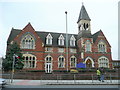
Dowty House, Cheltenham
High Victorian building is a care home on St. Margaret's Road, just north of the town centre.
Possibly used to be a school?
Image: © Jonathan Billinger
Taken: 23 Jan 2010
0.05 miles
3
Dowty House, Cheltenham
The property was originally built as a boy's orphanage in 1866
Image: © David Smith
Taken: 15 Aug 2022
0.05 miles
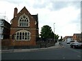
4
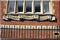
Cheltenham Council Schools Scroll
This is on the wall of the former Dunalley primary school, now converted to flats.
Image: © Terry Jacombs
Taken: 28 Mar 2012
0.06 miles
5
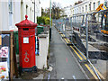
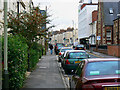
Penfold pillar box and St Paul's Road, Cheltenham
St Paul's Road is closed to traffic for the time being. Holes have been dug in it. At the left is the Victorian postbox seen in more detail here Image
Image: © Brian Robert Marshall
Taken: 5 Nov 2009
0.06 miles
6
![Cheltenham houses [118]](https://s0.geograph.org.uk/geophotos/06/91/62/6916212_e727af07_120x120.jpg)
Cheltenham houses [118]
This terrace of 19 houses, numbers 1 to 19 Clarence Square, were built in two phases - 1 to 14 in 1938 and 15 to 19 in 1849. Constructed in stuccoed brick with fine detailing under slate roofs with iron balconies and railings. Clarence Square was named after the Duke of Clarence, who became William IV in 1830. Listed, grade II, with details at: https://historicengland.org.uk/listing/the-list/list-entry/1386849
Cheltenham is located at the foot of the Cotswold scarp with the small River Chelt flowing through the town. After the discovery of mineral springs in 1716 Cheltenham became a spa town and many Regency houses and other buildings were erected. The town is home to the renowned Cheltenham Festival, four days of horse jump racing culminating in the Gold Cup, held annually in March at the nearby racecourse.
Image: © Michael Dibb
Taken: 19 May 2021
0.06 miles
7
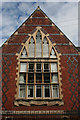
School Gable
The carved scroll below the ornate window reads 'Cheltenham Council Schools'
Image: © Anne Burgess
Taken: 7 Jul 2014
0.06 miles
8
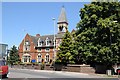
Dowty House, Cheltenham
Dowty House is on St Margaret's Road in Cheltenham. Originally the property was built as a boy's orphanage in 1866; it opened as a residential home for elderly women in November 1957. The building is not listed. Not sure of the origin of the name Dowty House and whether it has any connection to local engineer and entrepreneur Sir George Dowty.
Image: © Philip Halling
Taken: 10 Jul 2014
0.06 miles
9
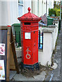
Penfold pillar box, St Paul's Road, Cheltenham
Here is one of the eight Penfold Victorian postboxes in the town. It looks rather neglected despite it being listed http://www.imagesofengland.org.uk/details/default.aspx?id=475899 It is situated outside a Chinese takeaway. It can be seen in its context here Image
Image: © Brian Robert Marshall
Taken: 5 Nov 2009
0.06 miles