IMAGES TAKEN NEAR TO
Swindon Road, CHELTENHAM, GL50 4BJ
Introduction
This page details the photographs taken nearby to Swindon Road, GL50 4BJ by members of the Geograph project.
The Geograph project started in 2005 with the aim of publishing, organising and preserving representative images for every square kilometre of Great Britain, Ireland and the Isle of Man.

There are currently over 7.5m images from over14,400 individuals and you can help contribute to the project by visiting https://www.geograph.org.uk
Image Map (Loading...)


Getting Data...Please wait
Leaflet Map data © OpenStreetMap
Images are licensed for reuse under creativecommons.org/licenses/by-sa/2.0
Notes
- Clicking on the map will re-center to the selected point.
- The higher the marker number, the further away the image location is from the centre of the postcode.
Image Listing (128 Images Found)
Images are licensed for reuse under creativecommons.org/licenses/by-sa/2.0
Image
Details
Distance
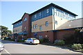
1
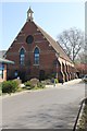
Old Chapel, St Paul's Medical Centre
Originally the chapel attached to the St Paul's Maternity Hospital, now used for medical services.
Image: © Terry Jacombs
Taken: 28 Mar 2012
0.02 miles
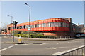
2
Royal Mail in Cheltenham
Sorting office on Poole Street.
Image: © Eirian Evans
Taken: 2 May 2011
0.04 miles
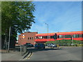
4
Post Office Sorting Office
Post Office Sorting Office on the corner of Poole Way and Swindon Road in Cheltenham.
Image: © Philip Halling
Taken: 17 Jan 2018
0.05 miles
5
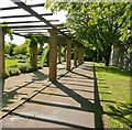
Winston Churchill Memorial Park, Cheltenham
Image: © Roger May
Taken: 1 Oct 2008
0.06 miles
6
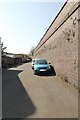
Railway retaining wall, off Swindon Road
The Cheltenham to Honeybourne railway line used to run on the embankment behind this wall. The short alley/lane off Swindon Road is unnamed.
Image: © Terry Jacombs
Taken: 28 Mar 2012
0.06 miles
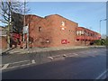
7
St Paul's Medical Centre
Built on the site of the St Paul's Maternity Hospital it is now the home for three surgeries relocated from other parts of the town and a number of ancillary medical services.
Image: © Terry Jacombs
Taken: 28 Mar 2012
0.06 miles
8
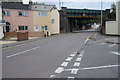
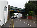
Swindon Road, Cheltenham
The railway bridge used to carry the Cheltenham to Stratford-upon-Avon line which closed in the 1970s.
Image: © Philip Halling
Taken: 13 Aug 2011
0.07 miles
9
Disused railway bridge over Swindon Road, Cheltenham
Now used by National Cycle Route 41.
Image: © JThomas
Taken: 13 Aug 2021
0.07 miles
10
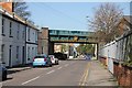
Swindon Road railwaybridge
This bridge carried the Cheltenham to Honeybourne line over Swindon Road.
Image: © Terry Jacombs
Taken: 28 Mar 2012
0.08 miles