IMAGES TAKEN NEAR TO
New Rutland Court, Swindon Road, CHELTENHAM, GL50 4AD
Introduction
This page details the photographs taken nearby to New Rutland Court, Swindon Road, GL50 4AD by members of the Geograph project.
The Geograph project started in 2005 with the aim of publishing, organising and preserving representative images for every square kilometre of Great Britain, Ireland and the Isle of Man.

There are currently over 7.5m images from over14,400 individuals and you can help contribute to the project by visiting https://www.geograph.org.uk
Image Map
Images are licensed for reuse under creativecommons.org/licenses/by-sa/2.0
Notes
- Clicking on the map will re-center to the selected point.
- The higher the marker number, the further away the image location is from the centre of the postcode.
Image Listing (280 Images Found)
Images are licensed for reuse under creativecommons.org/licenses/by-sa/2.0
Image
Details
Distance
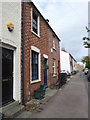
1
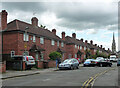
1-8 St Paul's Street South, Cheltenham
A development of semi-detached houses by Healing & Overbury in 1934-35.
Image: © Stephen Richards
Taken: 20 May 2015
0.02 miles
2
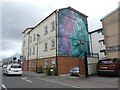
Block of flats with mural, on St George's Street
Image: © Roger Cornfoot
Taken: 27 Sep 2022
0.04 miles
4
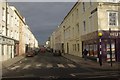
St George's Street, Cheltenham
Looking along St George's Street from its junction with High Street. The architecture is typical of the town.
Image: © Stephen McKay
Taken: 10 Dec 2011
0.07 miles
5
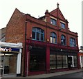
The Frog And Fiddle Public House, Cheltenham
The Frog and Fiddle Public House, Lower High Street, Cheltenham.
Image: © Colin Manton
Taken: 10 Feb 2015
0.07 miles
6
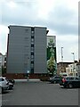
Blank end wall of hetel, with mural beyond, Cheltenham
The modular design of the corridors means that there are no room windows on the end wall of Holiday Inn Express, only the corridor windows.
Image: © David Smith
Taken: 15 Aug 2022
0.07 miles
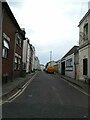
7
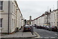
St Paul's Street North, Cheltenham
A residential street reflecting some of the character of Cheltenham.
Image: © Bill Boaden
Taken: 25 May 2018
0.07 miles
8
![Cheltenham houses [93]](https://s3.geograph.org.uk/geophotos/06/90/80/6908031_bb074ff4_120x120.jpg)
Cheltenham houses [93]
On the west side of Henrietta Street is this terrace of 32 houses, some now shops. The addresses are numbers 2 to 28 Henrietta Street, number 2 Swindon Road and numbers 271 to 277 High Street. Built circa 1815, in stuccoed brick under slate roofs. There are some late 19th and late 20th century shopfronts. There are further images of the terrace at Image, Image and Image Listed, grade II, with details at: https://historicengland.org.uk/listing/the-list/list-entry/1245586
Cheltenham is located at the foot of the Cotswold scarp with the small River Chelt flowing through the town. After the discovery of mineral springs in 1716 Cheltenham became a spa town and many Regency houses and other buildings were erected. The town is home to the renowned Cheltenham Festival, four days of horse jump racing culminating in the Gold Cup, held annually in March at the nearby racecourse.
Image: © Michael Dibb
Taken: 19 May 2021
0.07 miles