
IMAGES TAKEN NEAR TO
High Street, CHELTENHAM, GL50 3UA
Introduction
This page details the photographs taken nearby to High Street, GL50 3UA by members of the Geograph project.
The Geograph project started in 2005 with the aim of publishing, organising and preserving representative images for every square kilometre of Great Britain, Ireland and the Isle of Man.

There are currently over 7.5m images from over14,400 individuals and you can help contribute to the project by visiting https://www.geograph.org.uk
Image Map
Images are licensed for reuse under creativecommons.org/licenses/by-sa/2.0
Notes
- Clicking on the map will re-center to the selected point.
- The higher the marker number, the further away the image location is from the centre of the postcode.
Image Listing (701 Images Found)
Images are licensed for reuse under creativecommons.org/licenses/by-sa/2.0
Image
Details
Distance
1
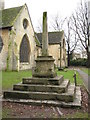
Preaching cross in Cheltenham
Preaching cross, thought to date from the 14th century, in the churchyard of St. Mary with St. Matthew, Cheltenham.
Image: © Philip Halling
Taken: 23 Jan 2010
0.01 miles
2
![Cheltenham features [23]](https://s3.geograph.org.uk/geophotos/06/90/80/6908047_4eeeb849_120x120.jpg)
Cheltenham features [23]
A general view of High Street.
Cheltenham is located at the foot of the Cotswold scarp with the small River Chelt flowing through the town. After the discovery of mineral springs in 1716 Cheltenham became a spa town and many Regency houses and other buildings were erected. The town is home to the renowned Cheltenham Festival, four days of horse jump racing culminating in the Gold Cup, held annually in March at the nearby racecourse.
Image: © Michael Dibb
Taken: 19 May 2021
0.01 miles
3
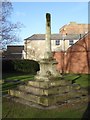
Cross in St Mary's churchyard
A cross, probably dating from the 15th century, in the churchyard of the Church of St Mary's, also known as Cheltenham Minister.
Image: © Philip Halling
Taken: 17 Jan 2018
0.01 miles
4
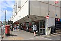
Under development!
Tesco metro in the High Street was a convenience store in every sense of the word. Shoppers who lived on the outskirts of Cheltenham, could catch a bus, and be dropped off, almost on Tesco's doorstop. It closed in August 2015, to make way for the completion of The Brewery development.
Image: © Helen Iwanczuk
Taken: 2 Aug 2015
0.02 miles
5
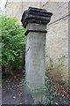
Gate pier to St Mary's churchyard
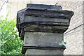
Gate pier at the entrance off Church Street into the churchyard of St Mary's Minster, Cheltenham. The pier and wall are Grade II listed and date from the mid-19th century. The pier is Grade II listed. Unusually the top of the pier is inscribed 'STICK NO BILLS'.
Image: © Philip Halling
Taken: 2 Dec 2018
0.02 miles
6
'STICK NO BILLS'
'STICK NO BILLS' is inscribed near the top of this Grade II gate pier at the entrance to St Mary's churchyard.
Image: © Philip Halling
Taken: 2 Dec 2018
0.02 miles
7
2 Pigs public house
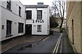
The 2 Pigs public house on Church Street in Cheltenham, formerly this was the Eight Bells public house dating from 1780-1820.
Image: © Philip Halling
Taken: 2 Dec 2018
0.03 miles
8

St Mary's Parish Church, Cheltenham
The parish church of St Mary largely dates from the C12th and late C13th and is hidden away in an oasis calm just off the High St. It has a fine old window tracery from the C13th and C14th although the present glass dates from 1875 to 1890. There are also a number of interesting memorials.
Image: © Simon Huguet
Taken: 15 Jul 2008
0.03 miles
9

St. Mary with St. Matthew, Cheltenham
The parish church of Cheltenham, and the town's oldest building.
Image: © Jonathan Billinger
Taken: 13 Dec 2008
0.03 miles
10

St. Mary with St. Matthew, Cheltenham
With squirrel and snow.
Image: © Jonathan Billinger
Taken: 9 Jan 2010
0.03 miles