IMAGES TAKEN NEAR TO
Jessop Avenue, CHELTENHAM, GL50 3SP
Introduction
This page details the photographs taken nearby to Jessop Avenue, GL50 3SP by members of the Geograph project.
The Geograph project started in 2005 with the aim of publishing, organising and preserving representative images for every square kilometre of Great Britain, Ireland and the Isle of Man.

There are currently over 7.5m images from over14,400 individuals and you can help contribute to the project by visiting https://www.geograph.org.uk
Image Map (Loading...)


Getting Data...Please wait
Leaflet Map data © OpenStreetMap
Images are licensed for reuse under creativecommons.org/licenses/by-sa/2.0
Notes
- Clicking on the map will re-center to the selected point.
- The higher the marker number, the further away the image location is from the centre of the postcode.
Image Listing (446 Images Found)
Images are licensed for reuse under creativecommons.org/licenses/by-sa/2.0
Image
Details
Distance
1
Site of Cheltenham Spa St James station, 1986
View ENE from St George's Road, near Great Western Road and/or Honeybourne Way, across the area formerly occupied by the GWR St James Station (terminus) and its sidings, which were accessed by a short branch from the former Malvern Road Junction and Station, just SW of which was Lansdown Junction - itself south of the surviving Cheltenham (Lansdown) Station. St James and Malvern Road stations were closed on 3/1/1966, the Goods station 31/10/1966. After that the whole area has been redeveloped, with new streets, office blocks, a superstore and industrial estate. Everything has changed so much even in the last 25 years that this view must be totally different now.
Image: © Ben Brooksbank
Taken: 21 Jun 1986
0.03 miles
2
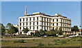
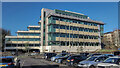
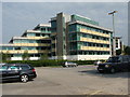
Festival House office block, Jessop Avenue, Cheltenham
Image: © David Smith
Taken: 25 Nov 2016
0.03 miles
4
Cheltenham Spa St. James railway station (site), Gloucestershire
Opened in 1894 as 'Cheltenham' by the Great Western Railway as the terminus of the line from Swindon, this station replaced an earlier 1847 terminus of the same name some 200m further west. This station was closed in 1966.
View south west at the former forecourt and carriage portico. The area has been redeveloped but a December 1965 image from the same viewpoint can be found at http://www.heritage-explorer.co.uk/web/he/searchdetail.aspx?id=9333
Image: © Nigel Thompson
Taken: 31 Mar 2017
0.05 miles
5
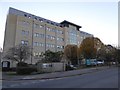
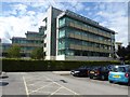
Jessop House, Cheltenham
Apparently this is a Grade 'A' office building in the 'business quarter' of Cheltenham.
Image: © Jonathan Billinger
Taken: 25 Nov 2022
0.05 miles
6
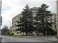
Office building near St James Square
The company occupying this building is iress, here it is viewed off the car park near St James Square though the address of the building is Jessop Avenue.
Image: © Philip Halling
Taken: 15 Sep 2017
0.06 miles
7
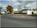
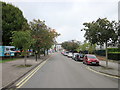
Mini-roundabout on St James Square
Mini-roundabout on the junction of St James Square and Jessop Avenue.
Image: © Philip Halling
Taken: 15 Sep 2017
0.06 miles
8
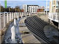
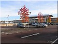
Waitrose Fountains
The fountains lie alongside the southern side of the building by the cafe.
Image: © Terry Jacombs
Taken: 19 Nov 2008
0.06 miles
9
Waitrose, Cheltenham
The supermarket is built on land which used to be the St James station in the centre of Cheltenham.
Image: © Terry Jacombs
Taken: 19 Nov 2008
0.06 miles
10
Office block and Chelt Walk car park
Image: © Ruth Sharville
Taken: 1 Jul 2009
0.06 miles