IMAGES TAKEN NEAR TO
New Street, CHELTENHAM, GL50 3QL
Introduction
This page details the photographs taken nearby to New Street, GL50 3QL by members of the Geograph project.
The Geograph project started in 2005 with the aim of publishing, organising and preserving representative images for every square kilometre of Great Britain, Ireland and the Isle of Man.

There are currently over 7.5m images from over14,400 individuals and you can help contribute to the project by visiting https://www.geograph.org.uk
Image Map (Loading...)


Getting Data...Please wait
Leaflet Map data © OpenStreetMap
Images are licensed for reuse under creativecommons.org/licenses/by-sa/2.0
Notes
- Clicking on the map will re-center to the selected point.
- The higher the marker number, the further away the image location is from the centre of the postcode.
Image Listing (287 Images Found)
Images are licensed for reuse under creativecommons.org/licenses/by-sa/2.0
Image
Details
Distance
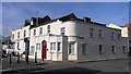
1
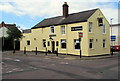
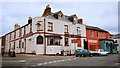
The Railway pub in Cheltenham
The Knapp Road side of the pub on the corner of New Street, opposite Station Street.
The pub is near the site of the former St James station where passenger services ended in 1966.
http://www.geograph.org.uk/photo/5135830 to the name sign on the right.
Image: © Jaggery
Taken: 3 Aug 2016
0.00 miles
2
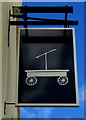
The Railway pub name sign, Cheltenham
The sign on the right here http://www.geograph.org.uk/photo/5135784 depicts a stylised handcar, such as this one http://www.geograph.org.uk/photo/3462208 in Tenterden. With the huge range of possibilities available, the choice of a handcar to symbolise a railway is interesting.
Image: © Jaggery
Taken: 3 Aug 2016
0.01 miles
3
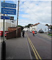
Blue signs facing New Road Cheltenham
An Unsuitable for HGVs (heavy goods vehicles) sign is between two cycle route signs.
Image: © Jaggery
Taken: 3 Aug 2016
0.01 miles
4
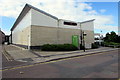
Waitrose in Cheltenham
The New Street side of the Waitrose in Honeybourne Way.
Image: © Jaggery
Taken: 3 Aug 2016
0.03 miles
5
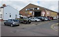
Ski Tyres, Cheltenham
At 73 New Street, on the corner of Grove Street.
Image: © Jaggery
Taken: 3 Aug 2016
0.03 miles
7
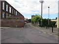
Knapp Lane, Cheltenham
On the south side of Knapp Road.
Image: © Jaggery
Taken: 3 Aug 2016
0.03 miles
8
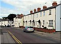
New Street houses, Cheltenham
On the north side of New Street between Grove Street and Burton Street.
Image: © Jaggery
Taken: 3 Aug 2016
0.05 miles
9
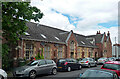
Former school, Devonshire Street, Cheltenham
Built as a charity school in 1846-47 by W.H. Knight.
Now housing.
Image: © Stephen Richards
Taken: 20 May 2015
0.05 miles
10
The Cavern, April 1999
Millennium photo project
Image: © Helen Iwanczuk
Taken: 19 Apr 1999
0.05 miles