IMAGES TAKEN NEAR TO
Brookbank Close, CHELTENHAM, GL50 3NS
Introduction
This page details the photographs taken nearby to Brookbank Close, GL50 3NS by members of the Geograph project.
The Geograph project started in 2005 with the aim of publishing, organising and preserving representative images for every square kilometre of Great Britain, Ireland and the Isle of Man.

There are currently over 7.5m images from over14,400 individuals and you can help contribute to the project by visiting https://www.geograph.org.uk
Image Map
Images are licensed for reuse under creativecommons.org/licenses/by-sa/2.0
Notes
- Clicking on the map will re-center to the selected point.
- The higher the marker number, the further away the image location is from the centre of the postcode.
Image Listing (140 Images Found)
Images are licensed for reuse under creativecommons.org/licenses/by-sa/2.0
Image
Details
Distance
1
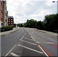
Honeybourne Way, Cheltenham
From Gloucester Road. The trees on the right are above the River Chelt.
Image: © Jaggery
Taken: 3 Aug 2016
0.02 miles
2
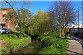
River Chelt
Small river in Cheltenham.
Image: © Wayland Smith
Taken: 17 Apr 2021
0.03 miles
3

The Hop Pole, Cheltenham
This pub, opposite the site of Image in Gloucester Road was the site of the terminus of the original Gloucester & Cheltenham Railway. This was actually a horse drawn tramway which ran largely along the roadside from Gloucester Docks and finishing in a set of wharves here to supply Cheltenham. This would have included the gasworks opposite. Another branch of the tramway ran to Leckhampton to carry stone from the quarries there. The tramway was largely abandoned with the coming of the "main line" railways although a short length at Leckhampton remained in use for many years to serve as a feeder to the standard gauge railway there. The location of the G & C terminus is commemorated by Image
Image: © David Stowell
Taken: 10 Nov 2006
0.04 miles
4
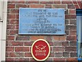
Plaque on the Hop Pole
The plaque just to the right of the doorway on Image in Gloucester Road commemorating the location of the terminus of the original horse drawn tramway from here to Gloucester Docks.
Image: © David Stowell
Taken: 10 Nov 2006
0.04 miles
5
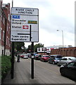
Directions sign on the approach to River Chelt Junction, Cheltenham
Facing westbound traffic on the B4633 Gloucester Road.
Image: © Jaggery
Taken: 3 Aug 2016
0.04 miles
6
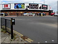
DW Sports Store, Cheltenham
Located in the Roundhouse, a 50 metre diameter circular building at 19 Gloucester Road, viewed in August 2016. A May 2009 Google Earth Street View shows JJB Sports Superstore in the Roundhouse.
Image: © Jaggery
Taken: 3 Aug 2016
0.05 miles
7
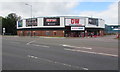
DW Sports Store, Cheltenham
Located in the Roundhouse, a 50 metre diameter circular building at 19 Gloucester Road, viewed in August 2016. A May 2009 Google Earth Street View shows JJB Sports Superstore in the Roundhouse.
Image: © Jaggery
Taken: 3 Aug 2016
0.06 miles
8

Derelict Market Street building, Cheltenham
A Sale Agreed notice is on the building in early August 2016.
Image: © Jaggery
Taken: 3 Aug 2016
0.06 miles
9
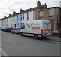
Magpie van in Cheltenham
A Magpie Carpentry & Building Services van is parked alongside this http://www.geograph.org.uk/photo/5140282 derelict Market Street building.
Image: © Jaggery
Taken: 3 Aug 2016
0.06 miles
10
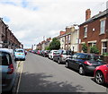
On-street parking, Market Street, Cheltenham
Towards Gloucester Road.
Image: © Jaggery
Taken: 3 Aug 2016
0.06 miles