IMAGES TAKEN NEAR TO
Park Street, CHELTENHAM, GL50 3NQ
Introduction
This page details the photographs taken nearby to Park Street, GL50 3NQ by members of the Geograph project.
The Geograph project started in 2005 with the aim of publishing, organising and preserving representative images for every square kilometre of Great Britain, Ireland and the Isle of Man.

There are currently over 7.5m images from over14,400 individuals and you can help contribute to the project by visiting https://www.geograph.org.uk
Image Map
Images are licensed for reuse under creativecommons.org/licenses/by-sa/2.0
Notes
- Clicking on the map will re-center to the selected point.
- The higher the marker number, the further away the image location is from the centre of the postcode.
Image Listing (191 Images Found)
Images are licensed for reuse under creativecommons.org/licenses/by-sa/2.0
Image
Details
Distance
1
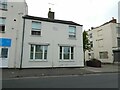
Barton Towers on A4019, Cheltenham
There must be a story behind this name ...!
Image: © David Smith
Taken: 15 Aug 2022
0.02 miles
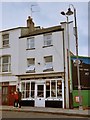
2
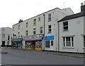
Shops, at the west end of Cheltenham High Street
Image: © Roger Cornfoot
Taken: 27 Sep 2022
0.03 miles
3
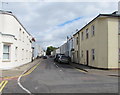
Burton Street Cheltenham
From New Street towards High Street.
Image: © Jaggery
Taken: 3 Aug 2016
0.03 miles
4
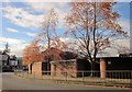
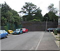
Wall and trees by Poole Way, Cheltenham
Autumnal trees occupying embayments in a smart brick wall beside the A 4019 northwest of the town centre.
Image: © Derek Harper
Taken: 25 Oct 2014
0.04 miles
5
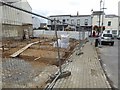
Development on the Lower High Street
This building beside a small car park on Lower High Street in Cheltenham is being redeveloped.
Image: © Philip Halling
Taken: 5 Sep 2017
0.05 miles
6
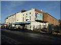
Former cinema and bingo hall
The former ABC Bingo Hall on the Lower High Street in Cheltenham closed in 2014. Previously this had been the Essoldo cinema between 1947 and 1964. Originally it was the Ritz Theatre which opened in 1937 and had seating for 919 people. The site is awaiting redevelopment, permission has been granted for residential housing.
Image: © Philip Halling
Taken: 17 Jan 2018
0.06 miles
7
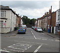
Stoneville Street, Cheltenham
Dead-end street extending for 95 metres from Gloucester Road.
Image: © Jaggery
Taken: 3 Aug 2016
0.07 miles
8
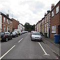
Stoneville Street, Cheltenham
Dead-end street on the southeast side of Gloucester Road.
Image: © Jaggery
Taken: 3 Aug 2016
0.07 miles
9
Wall at the southeast end of Stoneville Street, Cheltenham
95 metres from Gloucester Road, Stoneville Street ends at a high wall, behind which
is a combined footpath and cyclepath on the trackbed of the former Honeybourne Line railway.
The drainpipe on the right is perpendicular. The lamppost is not.
Image: © Jaggery
Taken: 3 Aug 2016
0.07 miles
10
Iddles Fishmongers - 1
This shop held great curiosity for me when I was younger, Although the premises seemed to be prepared for business (trays laid out) there never seemed to be any customers. The shop remained in this curious condition for many years, until the shop front was altered.
Image: © Helen Iwanczuk
Taken: Unknown
0.07 miles