IMAGES TAKEN NEAR TO
High Street, CHELTENHAM, GL50 3HQ
Introduction
This page details the photographs taken nearby to High Street, GL50 3HQ by members of the Geograph project.
The Geograph project started in 2005 with the aim of publishing, organising and preserving representative images for every square kilometre of Great Britain, Ireland and the Isle of Man.

There are currently over 7.5m images from over14,400 individuals and you can help contribute to the project by visiting https://www.geograph.org.uk
Image Map (Loading...)


Getting Data...Please wait
Leaflet Map data © OpenStreetMap
Images are licensed for reuse under creativecommons.org/licenses/by-sa/2.0
Notes
- Clicking on the map will re-center to the selected point.
- The higher the marker number, the further away the image location is from the centre of the postcode.
Image Listing (526 Images Found)
Images are licensed for reuse under creativecommons.org/licenses/by-sa/2.0
Image
Details
Distance
1
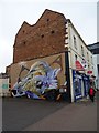
Shop with wall painting
Shop with wall painting Image] on its end on Lower High Street in Cheltenham. The artist is Curtis Hylton.
Image: © Philip Halling
Taken: 20 Mar 2019
0.02 miles
2
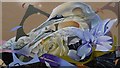
Wall painting of gannets
Wall painting of a pair of gannets on a wall on the side of a shop on Lower High Street in Cheltenham Image The artist is Curtis Hylton.
Image: © Philip Halling
Taken: 20 Mar 2019
0.02 miles
3
![Cheltenham houses [95]](https://s3.geograph.org.uk/geophotos/06/90/80/6908035_e585b675_120x120.jpg)
Cheltenham houses [95]
On the west side of Henrietta Street is this terrace of 32 houses, some now shops. The addresses are numbers 2 to 28 Henrietta Street, number 2 Swindon Road and numbers 271 to 277 High Street. Built circa 1815, in stuccoed brick under slate roofs. There are some late 19th and late 20th century shopfronts. There are further images of the terrace at Image, Image and Image Listed, grade II, with details at: https://historicengland.org.uk/listing/the-list/list-entry/1245586
Cheltenham is located at the foot of the Cotswold scarp with the small River Chelt flowing through the town. After the discovery of mineral springs in 1716 Cheltenham became a spa town and many Regency houses and other buildings were erected. The town is home to the renowned Cheltenham Festival, four days of horse jump racing culminating in the Gold Cup, held annually in March at the nearby racecourse.
Image: © Michael Dibb
Taken: 19 May 2021
0.02 miles
4

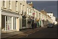
Junction of Henrietta Street with the Lower High Street
Pedestrian crossing on the junction of Henrietta Street with the Lower High Street in Cheltenham. The block where the Premier Inn is standing has been completely redeveloped in the last couple of years, previously it was an uninspiring 1960s shopping development. On the right there is a view up the Lower High Street. Here's a view of it from the other end of the street Image
Image: © Philip Halling
Taken: 28 Mar 2018
0.03 miles
5
![Cheltenham houses [98]](https://s0.geograph.org.uk/geophotos/06/90/80/6908064_1a3b26fb_120x120.jpg)
Cheltenham houses [98]
Number 11 St George's Place was built circa 1812. Constructed of stuccoed brick with a concealed roof and iron balconies. Listed, grade II, with details at: https://historicengland.org.uk/listing/the-list/list-entry/1387819
Cheltenham is located at the foot of the Cotswold scarp with the small River Chelt flowing through the town. After the discovery of mineral springs in 1716 Cheltenham became a spa town and many Regency houses and other buildings were erected. The town is home to the renowned Cheltenham Festival, four days of horse jump racing culminating in the Gold Cup, held annually in March at the nearby racecourse.
Image: © Michael Dibb
Taken: 19 May 2021
0.03 miles
6
Henrietta Street, Cheltenham
Looking along Henrietta Street from High Street in Cheltenham's town centre.
Image: © Stephen McKay
Taken: 10 Dec 2011
0.03 miles
7
![Cheltenham houses [99]](https://s0.geograph.org.uk/geophotos/06/90/80/6908072_6f304c09_120x120.jpg)
Cheltenham houses [99]
Numbers 15 and 17 St George's Place are two terraced houses with attached railings. Built circa 1805-20 with later additions and alterations. Constructed of stuccoed brick with a concealed roof and iron railings and balconies. Listed, grade II, with details at: https://historicengland.org.uk/listing/the-list/list-entry/1387821
Cheltenham is located at the foot of the Cotswold scarp with the small River Chelt flowing through the town. After the discovery of mineral springs in 1716 Cheltenham became a spa town and many Regency houses and other buildings were erected. The town is home to the renowned Cheltenham Festival, four days of horse jump racing culminating in the Gold Cup, held annually in March at the nearby racecourse.
Image: © Michael Dibb
Taken: 19 May 2021
0.03 miles
8
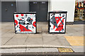
Street art, High Street, Cheltenham
The context is Image
Image: © Robin Stott
Taken: 14 Oct 2017
0.03 miles
9
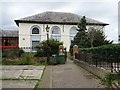
![Cheltenham buildings [62]](https://s1.geograph.org.uk/geophotos/06/90/80/6908081_da993407_120x120.jpg)
Cheltenham buildings [62]
Chapel House in Jenner Gardens was formerly Cheltenham Chapel, now used as offices. Built in 1809 with a 1980s extension. Constructed of stuccoed and painted brick under a slate roof. Listed, grade II, with details at: https://historicengland.org.uk/listing/the-list/list-entry/1387857
Cheltenham is located at the foot of the Cotswold scarp with the small River Chelt flowing through the town. After the discovery of mineral springs in 1716 Cheltenham became a spa town and many Regency houses and other buildings were erected. The town is home to the renowned Cheltenham Festival, four days of horse jump racing culminating in the Gold Cup, held annually in March at the nearby racecourse.
Image: © Michael Dibb
Taken: 19 May 2021
0.03 miles
10
Former Cheltenham Chapel
The former Cheltenham Chapel was built in 1809, today it has been converted and is used as an office.
Image: © Philip Halling
Taken: 31 Jul 2019
0.04 miles