IMAGES TAKEN NEAR TO
Bayshill Road, CHELTENHAM, GL50 3BA
Introduction
This page details the photographs taken nearby to Bayshill Road, GL50 3BA by members of the Geograph project.
The Geograph project started in 2005 with the aim of publishing, organising and preserving representative images for every square kilometre of Great Britain, Ireland and the Isle of Man.

There are currently over 7.5m images from over14,400 individuals and you can help contribute to the project by visiting https://www.geograph.org.uk
Image Map (Loading...)


Getting Data...Please wait
Leaflet Map data © OpenStreetMap
Images are licensed for reuse under creativecommons.org/licenses/by-sa/2.0
Notes
- Clicking on the map will re-center to the selected point.
- The higher the marker number, the further away the image location is from the centre of the postcode.
Image Listing (497 Images Found)
Images are licensed for reuse under creativecommons.org/licenses/by-sa/2.0
Image
Details
Distance
1
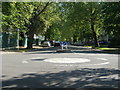
Roundabout at the junction of Bayshill Road and Parabola Road
Image: © Ruth Sharville
Taken: 3 Jun 2009
0.01 miles
2
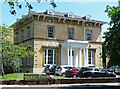
County House, Parabola Road, Cheltenham
Good Italianate villa of c1840. Grade II listed.
Now offices.
Image: © Stephen Richards
Taken: 21 May 2015
0.01 miles
3
![Cheltenham buildings [85]](https://s3.geograph.org.uk/geophotos/06/91/07/6910799_3508eeff_120x120.jpg)
Cheltenham buildings [85]
Now used as offices, County House, Bayshill Road was built circa 1840 and was restored in the 1980s. Constructed of ashlar with a slate roof. There is a central Doric porch and many internal features and fittings remain. Bayshill Road has been described as 'one of the great roads for architecture in all England'. Listed, grade II, with details at: https://historicengland.org.uk/listing/the-list/list-entry/1386736
Cheltenham is located at the foot of the Cotswold scarp with the small River Chelt flowing through the town. After the discovery of mineral springs in 1716 Cheltenham became a spa town and many Regency houses and other buildings were erected. The town is home to the renowned Cheltenham Festival, four days of horse jump racing culminating in the Gold Cup, held annually in March at the nearby racecourse.
Image: © Michael Dibb
Taken: 19 May 2021
0.02 miles
4
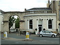
Archway and restaurant
In the Montpellier district of regency Cheltenham
Image: © Chris Allen
Taken: 7 Jul 2014
0.02 miles
5
![Cheltenham features [35]](https://s0.geograph.org.uk/geophotos/06/91/35/6913552_b669feb2_120x120.jpg)
Cheltenham features [35]
On the west side of Montpellier Street is this K6 telephone box, designed in 1935 by Sir Giles Gilbert Scott. Listed, grade II, with details at: https://historicengland.org.uk/listing/the-list/list-entry/1387126
Cheltenham is located at the foot of the Cotswold scarp with the small River Chelt flowing through the town. After the discovery of mineral springs in 1716 Cheltenham became a spa town and many Regency houses and other buildings were erected. The town is home to the renowned Cheltenham Festival, four days of horse jump racing culminating in the Gold Cup, held annually in March at the nearby racecourse.
Image: © Michael Dibb
Taken: 19 May 2021
0.03 miles
6

Montpellier Wine Bar
Wine bar in Cheltenham.
Image: © Wayland Smith
Taken: 25 Apr 2021
0.03 miles
7
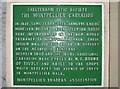
Plaque by the Montpellier Caryatids
The plaque describing the caryatids at Image The 1850s additional caryatids were reputedly "carved" simply by making moulds from the original pair sculpted by Rossi!
Image: © David Stowell
Taken: 1 Dec 2006
0.03 miles
8
Penfold pillar box and caryatids, Montpellier
One of Cheltenham's Penfold pillar boxes in Montpellier walk with some of the caryatids explained on Image
Image: © David Stowell
Taken: 1 Dec 2006
0.03 miles
9
The Courtyard
The modern shopping arcade in Montpellier Street designed by Sir Hugh Casson and opened 1985.
Image: © David Stowell
Taken: 1 Dec 2006
0.03 miles
10
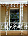
Detail of Queen's Parade, Parabola Road, Cheltenham
Close up of the ornate verandah.
Wider view Image
Image: © Stephen Richards
Taken: 21 May 2015
0.03 miles