IMAGES TAKEN NEAR TO
Suffolk Square, CHELTENHAM, GL50 2DX
Introduction
This page details the photographs taken nearby to Suffolk Square, GL50 2DX by members of the Geograph project.
The Geograph project started in 2005 with the aim of publishing, organising and preserving representative images for every square kilometre of Great Britain, Ireland and the Isle of Man.

There are currently over 7.5m images from over14,400 individuals and you can help contribute to the project by visiting https://www.geograph.org.uk
Image Map
Images are licensed for reuse under creativecommons.org/licenses/by-sa/2.0
Notes
- Clicking on the map will re-center to the selected point.
- The higher the marker number, the further away the image location is from the centre of the postcode.
Image Listing (380 Images Found)
Images are licensed for reuse under creativecommons.org/licenses/by-sa/2.0
Image
Details
Distance
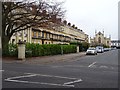
1
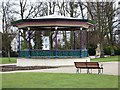
Bandstand, Montpellier Gardens, Cheltenham
The restored bandstand graces Montpellier Gardens with its elegant design.
Image: © Tom Jolliffe
Taken: 28 Jan 2010
0.03 miles
2
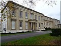
Montpellier House, Suffolk Square
The architect, Sir Robert Smirke, who designed the British Museum, lived in this house at the far end. The house is Grade II listed, see: https://historicengland.org.uk/listing/the-list/map-search
Image: © Philip Halling
Taken: 20 Nov 2018
0.04 miles
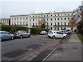
3
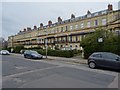
Houses on Suffolk Square
A terrace of 12 houses on the north side of Suffolk Square. The houses were built from 1832 to 1848. The buildings are Grade II* listed, see: https://historicengland.org.uk/listing/the-list/list-entry/1387971
Image: © Philip Halling
Taken: 20 Nov 2018
0.04 miles
4
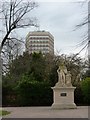
William IV statue Montpellier Gardens, Cheltenham
According to the plaque, this statue of William IV was erected by public subscription in 1833 to commemorate the King's coronation. It was moved from Imperial Gardens to the current Montpellier Gardens site in 1920. In the distance is the somewhat monolithic 1960s Eagle Tower in much the same shade of concrete as the stone of the statue. Green algae has grown on the head and shoulders of William.
Image: © Tom Jolliffe
Taken: 28 Jan 2010
0.04 miles
5
Suffolk Square
A terrace of 12 houses on the north side of Suffolk Square. The houses were built from 1832 to 1848. The church in the background is now a Zizzi Italian restaurant, the building is the former Church of St James.
Image: © Philip Halling
Taken: 20 Nov 2018
0.04 miles
6
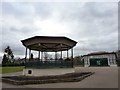
Gardens Gallery and Bandstand, Montpellier Gardens, Cheltenham
The Gardens Gallery building was restored in recent years.
Image: © Tom Jolliffe
Taken: 28 Jan 2010
0.05 miles
7
![Cheltenham houses [55]](https://s3.geograph.org.uk/geophotos/06/43/69/6436939_811ecba7_120x120.jpg)
Cheltenham houses [55]
These two terraced houses are now the northern part of Faithfull House, a residential care home. Built in the 1840s and converted in the 1970s. Many original internal features remain. The central part of Faithfull House is seen at Image and the southern part is seen at Image The northern part is listed, along with the area railings, grade II, with details at: https://historicengland.org.uk/listing/the-list/list-entry/1387985
Cheltenham is located at the foot of the Cotswold scarp with the small River Chelt flowing through the town. After the discovery of mineral springs in 1716 Cheltenham became a spa town and many Regency houses and other buildings were erected. The town is home to the renowned Cheltenham Festival, four days of horse jump racing culminating in the Gold Cup, held annually in March at the nearby racecourse.
Image: © Michael Dibb
Taken: 12 Mar 2020
0.05 miles
8
Houses overlooking Suffolk Square
Faithful House on the east side of Suffolk Square. Today this Grade II listed https://historicengland.org.uk/listing/the-list/list-entry/1387983 building is a residential care home.
Image: © Philip Halling
Taken: 20 Nov 2018
0.05 miles
9
![Cheltenham houses [57]](https://s3.geograph.org.uk/geophotos/06/43/69/6436943_0933761c_120x120.jpg)
Cheltenham houses [57]
These two terraced houses (part of a terrace of four) are now the southern part of Faithfull House, a residential care home. Built in the 1840s and converted in the 1970s. Many original internal features remain. The northern part of Faithfull House is seen at Image and the central part is seen at Image The southern and central parts are listed, along with the area railings, grade II, with details at: https://historicengland.org.uk/listing/the-list/list-entry/1387983
Cheltenham is located at the foot of the Cotswold scarp with the small River Chelt flowing through the town. After the discovery of mineral springs in 1716 Cheltenham became a spa town and many Regency houses and other buildings were erected. The town is home to the renowned Cheltenham Festival, four days of horse jump racing culminating in the Gold Cup, held annually in March at the nearby racecourse.
Image: © Michael Dibb
Taken: 12 Mar 2020
0.05 miles
10
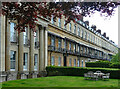
2-12 Suffolk Square, Cheltenham
A terrace of twelve houses, probably by Edward Jenkins, c1832-35. The ends have what amount to attached Composite porticos. Grade II* listed.
Another view: Image
Image: © Stephen Richards
Taken: 21 May 2015
0.05 miles