IMAGES TAKEN NEAR TO
Gratton Road, CHELTENHAM, GL50 2BU
Introduction
This page details the photographs taken nearby to Gratton Road, GL50 2BU by members of the Geograph project.
The Geograph project started in 2005 with the aim of publishing, organising and preserving representative images for every square kilometre of Great Britain, Ireland and the Isle of Man.

There are currently over 7.5m images from over14,400 individuals and you can help contribute to the project by visiting https://www.geograph.org.uk
Image Map (Loading...)


Getting Data...Please wait
Leaflet Map data © OpenStreetMap
Images are licensed for reuse under creativecommons.org/licenses/by-sa/2.0
Notes
- Clicking on the map will re-center to the selected point.
- The higher the marker number, the further away the image location is from the centre of the postcode.
Image Listing (95 Images Found)
Images are licensed for reuse under creativecommons.org/licenses/by-sa/2.0
Image
Details
Distance
1
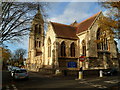
Church of St Philip & St James, Leckhampton, Cheltenham
Viewed from the corner of Grafton Road and Gratton Road.
Curiously, when the foundation stone for the original church was laid in 1838, it was dedicated to St Peter, but thereafter it was known as St Philip. At the consecration in 1840, St James was added to the name. By the late 1870s, the small church was no longer able to accommodate all those wishing to worship. It was replaced by the present church which was built in 1879-1882.
Image: © Jaggery
Taken: 25 Nov 2011
0.04 miles
2
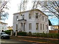
Grade II listed Greville House, Cheltenham
Located at 37 Gratton Road on the south side of the Church of St Philip & St James. http://www.geograph.org.uk/photo/3249740
Now in use as offices, Greville House was built in the 1820s as a villa. Grade II listed in March 1955.
Image: © Jaggery
Taken: 25 Nov 2011
0.05 miles
3
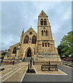
St. Philip and St. James, Leckhampton
Viewed from the newly-landscaped car park off Grafton Road.
Image: © Jonathan Billinger
Taken: 19 Sep 2023
0.05 miles
4
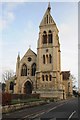
St Philip's and St James' church
St Philip's and St James' church on Grafton Road in Cheltenham is a Victorian church built in a gothic style.
Image: © Philip Halling
Taken: 23 Dec 2015
0.05 miles
5
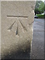
Ordnance Survey Cut Mark
This OS cut mark can be found on the SW angle of the Church of St Philip & St James. It marks a point 68.6318m above mean sea level.
Image: © Adrian Dust
Taken: 28 Jun 2015
0.05 miles
6
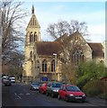
St Philip and St James', Painswick Road, Cheltenham
The church was consecrated in 1840 to cater for the growing population south of Cheltenham who had previously been served by St Peters Church, Leckhampton. Being surrounded by housing, it is difficult to get a good vantage point for a photograph.
Image: © Terry Jacombs
Taken: 20 Jan 2009
0.05 miles
7
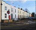
St Philip's Street, Cheltenham
Viewed from Norwood Road looking towards Bath Road.
On the left, the house with the red door is number 6 (Norwood Road).
The adjoining house (dark blue door) is number 23 (St Philip's Street).
Image: © Jaggery
Taken: 25 Nov 2011
0.05 miles
8
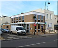
Lloyds TSB Bath Road Cheltenham branch
Bank branch at 189 Bath Road, on the corner of Suffolk Street.
Image: © Jaggery
Taken: 25 Nov 2011
0.06 miles
9
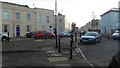
Andover Road, Norwood Road Junction
Five roads (six exits) meet here, Andover Road, Great Norwood Street, Norwood Road, Ashford Road and Grafton Road, Only two ways through now that the new barriers have been built.
Image: © Terry Jacombs
Taken: 20 Jan 2009
0.06 miles
10

Bath Road, Cheltenham
Houses and business premises; the design suggests they are twentieth century but in a conservative style to match the environs
Image: © David Smith
Taken: 29 Dec 2017
0.06 miles