IMAGES TAKEN NEAR TO
Upper Bath Street, CHELTENHAM, GL50 2BD
Introduction
This page details the photographs taken nearby to Upper Bath Street, GL50 2BD by members of the Geograph project.
The Geograph project started in 2005 with the aim of publishing, organising and preserving representative images for every square kilometre of Great Britain, Ireland and the Isle of Man.

There are currently over 7.5m images from over14,400 individuals and you can help contribute to the project by visiting https://www.geograph.org.uk
Image Map
Images are licensed for reuse under creativecommons.org/licenses/by-sa/2.0
Notes
- Clicking on the map will re-center to the selected point.
- The higher the marker number, the further away the image location is from the centre of the postcode.
Image Listing (149 Images Found)
Images are licensed for reuse under creativecommons.org/licenses/by-sa/2.0
Image
Details
Distance
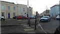
1
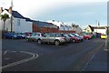
Bath Terrace Car Park, Cheltenham
The car park provides short term low cost car parking for shoppers in the Bath Road just to the east.
Image: © Terry Jacombs
Taken: 20 Jan 2009
0.03 miles
2
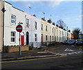
St Philip's Street, Cheltenham
Viewed from Norwood Road looking towards Bath Road.
On the left, the house with the red door is number 6 (Norwood Road).
The adjoining house (dark blue door) is number 23 (St Philip's Street).
Image: © Jaggery
Taken: 25 Nov 2011
0.03 miles
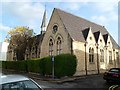
3
Old School Court, Great Norwood Street
The school is now used by a number of small businesses. The date over the door is MDCCCLXVI (1866).
Image: © Terry Jacombs
Taken: 20 Jan 2009
0.05 miles
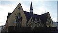
4
Old School Court, Cheltenham
Looking at first glance like a church, this building on the corner of Great Norwood Street and Upper Bath Street was formerly a school, now in residential use. The far end of the building is along Bethesda Street.
Image: © Jaggery
Taken: 25 Nov 2011
0.05 miles
5
Andover Road, Norwood Road Junction
Five roads (six exits) meet here, Andover Road, Great Norwood Street, Norwood Road, Ashford Road and Grafton Road, Only two ways through now that the new barriers have been built.
Image: © Terry Jacombs
Taken: 20 Jan 2009
0.05 miles
6
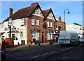
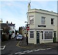
The Exmouth Arms, Cheltenham
Bath Road pub, opposite the Naunton Parade/Exmouth Street junction.
Image: © Jaggery
Taken: 25 Nov 2011
0.06 miles
7
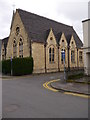
Old School Court
Old School Court at the junction of Great Norwood Street and Upper Bath Street. Now converted into flats.
Image: © K K Stears
Taken: 12 Apr 2015
0.06 miles
8
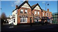
The Exmouth Arms
A busy pub in the middle of the Bath Road shopping area south of Cheltenham centre.
Image: © Terry Jacombs
Taken: 18 Jan 2009
0.06 miles
9
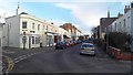
Great Norwood Street
A mixture of small shops and 19th/early 20th century buildings line the street
Image: © Terry Jacombs
Taken: 20 Jan 2009
0.06 miles
10
Corner of Great Norwood Street and Andover Road, Cheltenham
There is an old-style white-on-black street name sign on the corner building.
Just out of shot on the left is the Goose Chase Quilting shop. http://www.geograph.org.uk/photo/3249685
Image: © Jaggery
Taken: 25 Nov 2011
0.06 miles