IMAGES TAKEN NEAR TO
Birdlip, GLOUCESTER, GL4 8LJ
Introduction
This page details the photographs taken nearby to GL4 8LJ by members of the Geograph project.
The Geograph project started in 2005 with the aim of publishing, organising and preserving representative images for every square kilometre of Great Britain, Ireland and the Isle of Man.

There are currently over 7.5m images from over14,400 individuals and you can help contribute to the project by visiting https://www.geograph.org.uk
Image Map
Images are licensed for reuse under creativecommons.org/licenses/by-sa/2.0
Notes
- Clicking on the map will re-center to the selected point.
- The higher the marker number, the further away the image location is from the centre of the postcode.
Image Listing (7 Images Found)
Images are licensed for reuse under creativecommons.org/licenses/by-sa/2.0
Image
Details
Distance
1
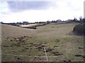
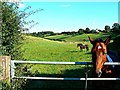
Horses Grazing, Sidelands
Looking south west across the grassland to Sidelands on the hilltop.
Image: © Bob Embleton
Taken: 2 Mar 2006
0.02 miles
3
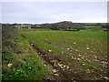
Arable land near Sidelands
Looking north towards Hawcote Hill, 294m. in the next square to the north.
Image: © Jonathan Billinger
Taken: 6 Dec 2013
0.12 miles
4
Horse, near Sidelands Farm, Birdlip
One of several in the field enjoying the late summer sunshine. In the background are some jumps made from logs and plastic drums, which are functional if not necessarily likely to win awards from the Design Council.
Image: © Brian Robert Marshall
Taken: 2 Sep 2013
0.14 miles
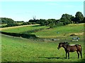
5
Horses, near Sidelands Farm, Birdlip
The gently rolling countryside is typical of this part of the Cotswolds, as are the horses and the flies. At the upper right are the buildings that together comprise Sidelands Farm.
Image: © Brian Robert Marshall
Taken: 2 Sep 2013
0.14 miles
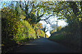
6
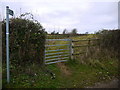
Bridleway to Blacklains
Nice rider-friendly gate.
Image: © Jonathan Billinger
Taken: 6 Dec 2013
0.15 miles
7
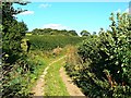
Footpath near Birdlip
The footpath continues generally south-east until it enters the village of Brimpsfield from the north after about a kilometre. Almost certainly it doubles as an access route for farm vehicles.
Image: © Brian Robert Marshall
Taken: 2 Sep 2013
0.19 miles