IMAGES TAKEN NEAR TO
Cranham, GLOUCESTER, GL4 8HX
Introduction
This page details the photographs taken nearby to GL4 8HX by members of the Geograph project.
The Geograph project started in 2005 with the aim of publishing, organising and preserving representative images for every square kilometre of Great Britain, Ireland and the Isle of Man.

There are currently over 7.5m images from over14,400 individuals and you can help contribute to the project by visiting https://www.geograph.org.uk
Image Map
Images are licensed for reuse under creativecommons.org/licenses/by-sa/2.0
Notes
- Clicking on the map will re-center to the selected point.
- The higher the marker number, the further away the image location is from the centre of the postcode.
Image Listing (6 Images Found)
Images are licensed for reuse under creativecommons.org/licenses/by-sa/2.0
Image
Details
Distance
1
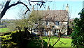
Cotswolds house
A fine stone house tucked away beside Mann's Court.
Image: © Jonathan Billinger
Taken: 11 Feb 2016
0.14 miles
2
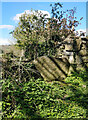
Stone Stile, Cranham/Sheepscombe
This stile served the old footpath through the grounds of Mann's Court, which was re-routed around the periphery of the garden wall. The close-up view looking over is Image
Image: © Lenneke Jansens
Taken: 15 Apr 2021
0.15 miles
3
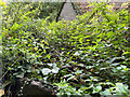
Stone Stile, Cranham/Sheepscombe
This stile served the old footpath through the grounds of Mann's Court, which was re-routed around the periphery of the garden wall. Since Gloucestershire footpath MCR35 was re-directed the brambles have taken over. The context view looking West is Image
Image: © Jayne Tovey
Taken: 25 Sep 2022
0.15 miles
4
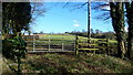
Gate and field
Opposite Mann's Court with a glimpse of Cranham church tower in the centre distance.
Image: © Jonathan Billinger
Taken: 11 Feb 2016
0.17 miles
5
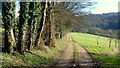
Track and footpath to Haregrove
Saltridge Common Wood on the hillside beyond.
Image: © Jonathan Billinger
Taken: 11 Feb 2016
0.19 miles
6
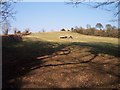
Pasture near Mann's Court
Looking north east towards the church.
Image: © Bob Embleton
Taken: 15 Mar 2006
0.22 miles