IMAGES TAKEN NEAR TO
Portway, GLOUCESTER, GL4 8DS
Introduction
This page details the photographs taken nearby to Portway, GL4 8DS by members of the Geograph project.
The Geograph project started in 2005 with the aim of publishing, organising and preserving representative images for every square kilometre of Great Britain, Ireland and the Isle of Man.

There are currently over 7.5m images from over14,400 individuals and you can help contribute to the project by visiting https://www.geograph.org.uk
Image Map
Images are licensed for reuse under creativecommons.org/licenses/by-sa/2.0
Notes
- Clicking on the map will re-center to the selected point.
- The higher the marker number, the further away the image location is from the centre of the postcode.
Image Listing (6 Images Found)
Images are licensed for reuse under creativecommons.org/licenses/by-sa/2.0
Image
Details
Distance
1
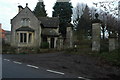
Lodge to Prinknash Park
Lodge and entrance gates Prinknash Park which is where Prinknash Abbey is situated.
Image: © Philip Halling
Taken: 2 Jan 2011
0.03 miles
2
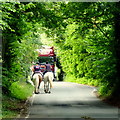
Traffic on The Portway
Two riders ascending the hill whilst a piano removal lorry bears down towards them.
Image: © Jonathan Billinger
Taken: 12 Aug 2013
0.16 miles
3
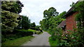
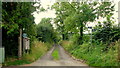
Valley Lane
A dead-end lane off The Portway.
Image: © Jonathan Billinger
Taken: 12 Aug 2013
0.18 miles
4
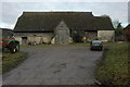
Barn at Manor Farm
Large tradictional stone-built and timber barn at Manor Farm in Upton St Leonards.
Image: © Philip Halling
Taken: 2 Jan 2011
0.19 miles
5
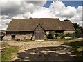
Barn, Upton St. Leonards
This magnificent barn is at Manor Farm, on Portway. The following is taken from the description on http://www.stroud.gov.uk/info/listed_buildings/upton_stleonards.pdf :
"Large barn with attached stable at east end. C15, possibly
earlier; late C17 stable. Very large coursed and squared
limestone; timber framing; coursed rubble to stable; stone slate
roof (clay pantile to north slope). Off-centre south porch to 6-
bay barn; stable with loft. South side: stone base walls with
chamfered plinth and buttresses; gabled porch with plank barn doors
and outshut to right; weatherboarded porch gable and upper part of
barn walls; low opening in wall to left of porch with plank doors;
plain stone side wall to stable. East end: barn end is half-hipped
with small gablet, gabled stable with 2 stable doors having timber
lintels; central loft door over with timber lintels; 3 rows of
a pigeon holes in gable apex. North side: weatherboarded above
buttressed stone base walls as to south; central porch with raised
sprocketted roof; attached shelter sheds are not of special
interest. West end: weatherboarded half-hipped gable end with
gablet above buttressed stone base wall.
Interior has 7 raised cruck trusses with very high cambered collars
and arched bracing; 2 rows of purlins and ogee-curved wind bracing:
close studded end walls; small framing along sides. Internal span of
approximately 8.2m across feet of crucks. Rafters and framing are
original: C15 work is largely intact with little evidence of
repair or replacement. C19 iron tie-rods sag and appear
unnecessary. A lofty and elegant structure. Important barn and
one of the best in the county. Possibly built as Tithe Barn for Gloucester
Abbey. (N.W. Alcock, Cruck Construction: An Introduction and Catalogue, Q 1981)."
Image: © Derek Harper
Taken: 4 Jul 2008
0.20 miles
6
Path at the end of Valley Lane
Don't be fooled - it runs parallel to the drive, not along it!
Image: © Jonathan Billinger
Taken: 12 Aug 2013
0.22 miles