IMAGES TAKEN NEAR TO
Upton Hill, GLOUCESTER, GL4 8DE
Introduction
This page details the photographs taken nearby to Upton Hill, GL4 8DE by members of the Geograph project.
The Geograph project started in 2005 with the aim of publishing, organising and preserving representative images for every square kilometre of Great Britain, Ireland and the Isle of Man.

There are currently over 7.5m images from over14,400 individuals and you can help contribute to the project by visiting https://www.geograph.org.uk
Image Map
Images are licensed for reuse under creativecommons.org/licenses/by-sa/2.0
Notes
- Clicking on the map will re-center to the selected point.
- The higher the marker number, the further away the image location is from the centre of the postcode.
Image Listing (5 Images Found)
Images are licensed for reuse under creativecommons.org/licenses/by-sa/2.0
Image
Details
Distance
1
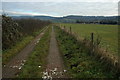
Bridleway to Moorend
This track above Upton St Leonards gives access to some farm buildings and then continues as a bridleway to Moorend.
Image: © Philip Halling
Taken: 2 Jan 2011
0.08 miles
2
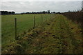
Track to the east of the B4073
This track is the route of a bridleway from Moorend.
Image: © Philip Halling
Taken: 2 Jan 2011
0.14 miles
3
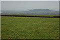
View from above Upton St Leonards
View from a bridleway above Upton St Leonards. The hill in the middle distance is Chosen Hill, also known as Churchdown Hill, Bredon Hill can be seen in the background and Tewkesbury Abbey is caught in the sun to the left.
Image: © Philip Halling
Taken: 2 Jan 2011
0.16 miles
4
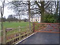
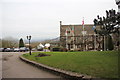
Hazel Grove
Looking west south west up the drive.
Image: © Bob Embleton
Taken: 16 Mar 2006
0.19 miles