IMAGES TAKEN NEAR TO
Purslane Close, GLOUCESTER, GL4 6UZ
Introduction
This page details the photographs taken nearby to Purslane Close, GL4 6UZ by members of the Geograph project.
The Geograph project started in 2005 with the aim of publishing, organising and preserving representative images for every square kilometre of Great Britain, Ireland and the Isle of Man.

There are currently over 7.5m images from over14,400 individuals and you can help contribute to the project by visiting https://www.geograph.org.uk
Image Map
Images are licensed for reuse under creativecommons.org/licenses/by-sa/2.0
Notes
- Clicking on the map will re-center to the selected point.
- The higher the marker number, the further away the image location is from the centre of the postcode.
Image Listing (11 Images Found)
Images are licensed for reuse under creativecommons.org/licenses/by-sa/2.0
Image
Details
Distance
1
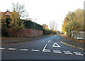
Juniper Avenue, Matson, Gloucester
This is the SE end of Juniper Avenue, viewed from Matson Lane.
Image: © Jaggery
Taken: 22 Nov 2013
0.13 miles
2
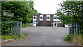
SENSS facility, Matson
Attached to the rear of the Moat Primary School buildings, this council-run unit serves people with Special Educational Needs.
Image: © Jonathan Billinger
Taken: 5 Aug 2013
0.17 miles
3
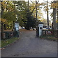
Welcome to Selwyn Care, Matson, Gloucester
The Welcome signs are on fences at the Matson Lane entrance to Matson House.
Image: © Jaggery
Taken: 22 Nov 2013
0.18 miles
4
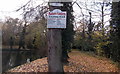
Matson Casters Angling Club board, Gloucester
The information and rules board is on a tree at the edge of a pond http://www.geograph.org.uk/photo/3980047 near Matson Lane.
The small notice above the board shows NO NIGHT FISHING.
Image: © Jaggery
Taken: 22 Nov 2013
0.20 miles
5
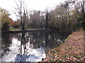
Fishing pond, Matson, Gloucester
Viewed from the edge of Matson Lane.
A Matson Casters Angling Club information and rules board is on a tree nearby. http://www.geograph.org.uk/photo/3980043
Image: © Jaggery
Taken: 22 Nov 2013
0.21 miles
6
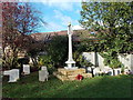
Matson War Memorial, Gloucester
In the churchyard of St Katharine's Church, http://www.geograph.org.uk/photo/3980071 Matson Lane, erected
IN MEMORY OF THOSE WHO DIED FOR THE RIGHT IN THE WAR, 1914-1918.
Image: © Jaggery
Taken: 22 Nov 2013
0.21 miles
7
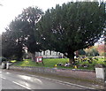
Churchyard perimeter trees, Matson, Gloucester
Trees on the Matson Lane side of the churchyard partially hide St Katharine's Church. http://www.geograph.org.uk/photo/3980065
Image: © Jaggery
Taken: 22 Nov 2013
0.22 miles
8
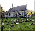
Church and churchyard, Matson, Gloucester
St Katharine's Church (Anglican) viewed from Matson Lane.
Image: © Jaggery
Taken: 22 Nov 2013
0.23 miles
9
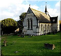
NW side of St Katharine's Church, Matson, Gloucester
Anglican church on the west side of Matson Lane.
Image: © Jaggery
Taken: 22 Nov 2013
0.23 miles
10
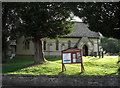
St Katharine's Church, Matson
On Matson Lane near the dry ski slope.
Image: © michael ely
Taken: 3 Sep 2010
0.24 miles