IMAGES TAKEN NEAR TO
Sorrel Close, GLOUCESTER, GL4 6UU
Introduction
This page details the photographs taken nearby to Sorrel Close, GL4 6UU by members of the Geograph project.
The Geograph project started in 2005 with the aim of publishing, organising and preserving representative images for every square kilometre of Great Britain, Ireland and the Isle of Man.

There are currently over 7.5m images from over14,400 individuals and you can help contribute to the project by visiting https://www.geograph.org.uk
Image Map
Images are licensed for reuse under creativecommons.org/licenses/by-sa/2.0
Notes
- Clicking on the map will re-center to the selected point.
- The higher the marker number, the further away the image location is from the centre of the postcode.
Image Listing (3 Images Found)
Images are licensed for reuse under creativecommons.org/licenses/by-sa/2.0
Image
Details
Distance
1
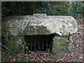
Robins Wood Hill Spring Cross
The spring provided water to the city of Gloucester for more than 400 years. in the reign of Edward 3rd, it became the subject of a dispute between the Grey Friars and St Peters Abbey, concerning the quantity of water the former was to receive, which was settled by the King in 1350.
Image: © Christopher Clift
Taken: Unknown
0.20 miles
3
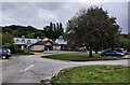
Cafe and car park at the Robinswood Hill Country Park
Image: © Mat Fascione
Taken: 4 Oct 2021
0.24 miles