IMAGES TAKEN NEAR TO
Finlay Road, GLOUCESTER, GL4 6TQ
Introduction
This page details the photographs taken nearby to Finlay Road, GL4 6TQ by members of the Geograph project.
The Geograph project started in 2005 with the aim of publishing, organising and preserving representative images for every square kilometre of Great Britain, Ireland and the Isle of Man.

There are currently over 7.5m images from over14,400 individuals and you can help contribute to the project by visiting https://www.geograph.org.uk
Image Map
Images are licensed for reuse under creativecommons.org/licenses/by-sa/2.0
Notes
- Clicking on the map will re-center to the selected point.
- The higher the marker number, the further away the image location is from the centre of the postcode.
Image Listing (19 Images Found)
Images are licensed for reuse under creativecommons.org/licenses/by-sa/2.0
Image
Details
Distance
1
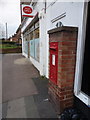
Gloucester: postbox № GL4 61, Finlay Road
A George V-reign postbox set into a brick pillar outside Finlay Road Post Office. Finlay Road is a busy part of the main A38 skirting round the city centre, and this stretch is a parallel service road for the shopfronts.
Image: © Chris Downer
Taken: 13 Nov 2012
0.09 miles
2
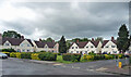
Northfield Square, Gloucester
Rendered semis by LaTrobe & Weston, 1913-14.
Image: © Stephen Richards
Taken: 19 May 2015
0.09 miles
3
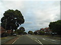
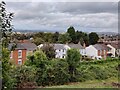
Finlay Road, Tuffley
Living in what used to be Middlesex this could be just about anywhere in Harrow or Edgware.
Image: © David Howard
Taken: 28 Jul 2018
0.11 miles
4
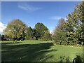
Former Tuffley Junction
The railway line once split off to the left as can be seen in another image on this gridsquare. The location is now growing birches and brambles but just beyond the photo the house of Larkspear Close have been built on the route of the old track. Viewed from the Stroud Road bridge.
Image: © David Collins
Taken: 11 Jan 2007
0.11 miles
5
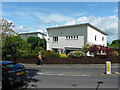
166 Reservoir Road, Gloucester
Someting of a turn-up, one of a trio of modernist houses, by Gordon Payne, 1950.
Image: © Stephen Richards
Taken: 19 May 2015
0.13 miles
6
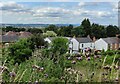
View north from the car park at the Robinswood Hill Country Park
Image: © Mat Fascione
Taken: 3 Jul 2022
0.14 miles
7
View north from the car park at the Robinswood Hill Country Park
Image: © Mat Fascione
Taken: 4 Oct 2021
0.15 miles
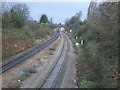
9
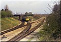
Tuffley Junction
A DMU from Gloucester Eastgate approaches Tuffley Junction on the former Midland Railway line. This line was plagued with level crossings and was eventually closed and lifted in the 1970s when all traffic was diverted into Gloucester Central. The line on the right, today's main line, is the former Great Western Main line from Gloucester South Junction. The course of line can be seen on the OS maps by examining the fence lines behind the buildings on Stroud Road.
Image: © David Stowell
Taken: Unknown
0.15 miles
10
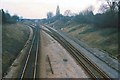
Tuffley Junction
Image shortly after closure of the ex-Midland Route into Gloucester as seen from the rusting rails on the route to the left. See Image for a view of the same place 30 years later.
Image: © David Stowell
Taken: Unknown
0.15 miles