IMAGES TAKEN NEAR TO
Reservoir Road, GLOUCESTER, GL4 6SB
Introduction
This page details the photographs taken nearby to Reservoir Road, GL4 6SB by members of the Geograph project.
The Geograph project started in 2005 with the aim of publishing, organising and preserving representative images for every square kilometre of Great Britain, Ireland and the Isle of Man.

There are currently over 7.5m images from over14,400 individuals and you can help contribute to the project by visiting https://www.geograph.org.uk
Image Map
Images are licensed for reuse under creativecommons.org/licenses/by-sa/2.0
Notes
- Clicking on the map will re-center to the selected point.
- The higher the marker number, the further away the image location is from the centre of the postcode.
Image Listing (25 Images Found)
Images are licensed for reuse under creativecommons.org/licenses/by-sa/2.0
Image
Details
Distance
1
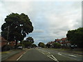
Finlay Road, Tuffley
Living in what used to be Middlesex this could be just about anywhere in Harrow or Edgware.
Image: © David Howard
Taken: 28 Jul 2018
0.05 miles
2
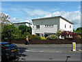
166 Reservoir Road, Gloucester
Someting of a turn-up, one of a trio of modernist houses, by Gordon Payne, 1950.
Image: © Stephen Richards
Taken: 19 May 2015
0.07 miles
3
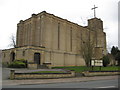
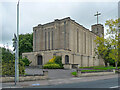
St Barnabas church
St Barnabas church was built in 1938-40 and is described by Pevsner as 'the best interwar church in the county'.
Image: © Philip Halling
Taken: 20 Mar 2010
0.08 miles
4
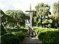
War Memorial, Tuffley
Commemorates the fallen of the Second World War https://historicengland.org.uk/listing/the-list/list-entry/1420087?section=official-list-entry
Image: © Jonathan Thacker
Taken: 3 Oct 2023
0.10 miles
5
St Barnabas, Stroud Road, Gloucester
By N.F. Cachemaille-Day, 1938-40, "the best interwar church in the county". Grade II* listed.
Image: © Stephen Richards
Taken: 19 May 2015
0.11 miles
6
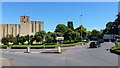
St. Barnabas' church, Gloucester
At the busy intersection of the Stroud Road and the A38 ring road.
The striking building in pale coloured materials is late-art-deco period 1938-40.
Image: © Jonathan Billinger
Taken: 10 Aug 2012
0.12 miles
7
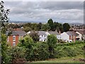
View north from the car park at the Robinswood Hill Country Park
Image: © Mat Fascione
Taken: 4 Oct 2021
0.13 miles
8
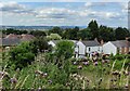
View north from the car park at the Robinswood Hill Country Park
Image: © Mat Fascione
Taken: 3 Jul 2022
0.13 miles
9
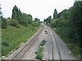
Site of Tuffley Junction
From almost the same spot as Image but some 30 years later, and little sign of remains of the former Midland line at this point.
Image: © David Stowell
Taken: 18 Sep 2005
0.13 miles
10
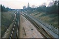
Tuffley Junction
Image shortly after closure of the ex-Midland Route into Gloucester as seen from the rusting rails on the route to the left. See Image for a view of the same place 30 years later.
Image: © David Stowell
Taken: Unknown
0.13 miles