IMAGES TAKEN NEAR TO
Marlborough Crescent, GLOUCESTER, GL4 6QA
Introduction
This page details the photographs taken nearby to Marlborough Crescent, GL4 6QA by members of the Geograph project.
The Geograph project started in 2005 with the aim of publishing, organising and preserving representative images for every square kilometre of Great Britain, Ireland and the Isle of Man.

There are currently over 7.5m images from over14,400 individuals and you can help contribute to the project by visiting https://www.geograph.org.uk
Image Map
Images are licensed for reuse under creativecommons.org/licenses/by-sa/2.0
Notes
- Clicking on the map will re-center to the selected point.
- The higher the marker number, the further away the image location is from the centre of the postcode.
Image Listing (37 Images Found)
Images are licensed for reuse under creativecommons.org/licenses/by-sa/2.0
Image
Details
Distance
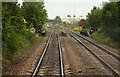
1
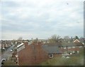
Tredworth, Gloucester: view from the train towards the city centre
Gloucester Cathedral is visible on the horizon.
Image: © Christopher Hilton
Taken: 18 Mar 2013
0.07 miles

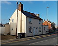
3
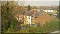
Matson Place, Tredworth, Gloucester
A terrace seen from the main railway line. The first three houses in the terrace fall within this square. The street, like the neighbouring Melbourne Street (houses to the right), is a cul-de-sac off Hatherley Road that ends at the railway embankment.
Image: © Derek Harper
Taken: 10 Apr 2015
0.09 miles
4
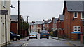
Hatherley Road, Gloucester
Tredworth/Barton suburbs of the city.
Image: © Jonathan Billinger
Taken: 24 Dec 2012
0.11 miles
5
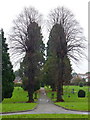
Tredworth cemetery, 2
View along the northern pathway.
Image: © Jonathan Billinger
Taken: 24 Dec 2012
0.14 miles
6
Church of God, Hatherley Road, Gloucester
A Seventh Day place of worship.
http://www.cog7thday.org.uk/StandardPage.aspx?Key=OurBranches&Id=Gloucester
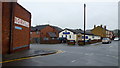
The Norville sign is on the old premises of a spectacle manufacturer in the city.
http://www.norville.co.uk/
Image: © Jonathan Billinger
Taken: 24 Dec 2012
0.15 miles
7
Houses at the northern end of Painswick Road, Gloucester
The houses are opposite the Chequers Road junction.
Image: © Jaggery
Taken: 22 Nov 2013
0.15 miles
8

Massey Road, Gloucester
Viewed from Barton Street.
Image: © Jaggery
Taken: 22 Nov 2013
0.15 miles
10

Vicarage Road, Gloucester
Viewed across Upton Street looking towards Adelaide Street.
Image: © Jaggery
Taken: 22 Nov 2013
0.15 miles