IMAGES TAKEN NEAR TO
Cemetery Road, GLOUCESTER, GL4 6PB
Introduction
This page details the photographs taken nearby to Cemetery Road, GL4 6PB by members of the Geograph project.
The Geograph project started in 2005 with the aim of publishing, organising and preserving representative images for every square kilometre of Great Britain, Ireland and the Isle of Man.

There are currently over 7.5m images from over14,400 individuals and you can help contribute to the project by visiting https://www.geograph.org.uk
Image Map
Images are licensed for reuse under creativecommons.org/licenses/by-sa/2.0
Notes
- Clicking on the map will re-center to the selected point.
- The higher the marker number, the further away the image location is from the centre of the postcode.
Image Listing (20 Images Found)
Images are licensed for reuse under creativecommons.org/licenses/by-sa/2.0
Image
Details
Distance
1
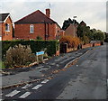
Old Painswick Road, Gloucester
Part of a boomerang-shaped section of the old road to Painswick,
on the east side of the straight course of the B4073 Painswick Road.
Image: © Jaggery
Taken: 22 Nov 2013
0.12 miles
2
Painswick Road houses, Gloucester
The houses are NW of The Lampreys junction. http://www.geograph.org.uk/photo/3965535
Image: © Jaggery
Taken: 22 Nov 2013
0.13 miles
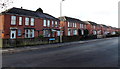
3
Chequers Road, Gloucester
Houses at the NW end of Chequers Road, viewed from the corner of Painswick Road.
Image: © Jaggery
Taken: 22 Nov 2013
0.16 miles
4
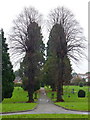
Tredworth cemetery, 2
View along the northern pathway.
Image: © Jonathan Billinger
Taken: 24 Dec 2012
0.17 miles
5
Askwith Road bungalows, Gloucester
Viewed from the western (Painswick Road) end.
Image: © Jaggery
Taken: 22 Nov 2013
0.18 miles
6

The Lampreys, Gloucester
The Lampreys is a long residential cul-de-sac extending from Painswick Road
on this side to the edge of the A38 Eastern Avenue about 200 metres ahead.
Image: © Jaggery
Taken: 22 Nov 2013
0.18 miles
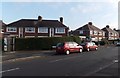
7
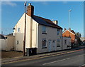
Houses at the northern end of Painswick Road, Gloucester
The houses are opposite the Chequers Road junction.
Image: © Jaggery
Taken: 22 Nov 2013
0.19 miles
8
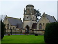
Tredworth cemetery, 3
Gothic-style chapel within this Victorian cemetery.
Image: © Jonathan Billinger
Taken: 24 Dec 2012
0.19 miles
9
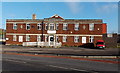
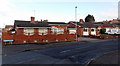
Chequers Bridge Community Centre, Gloucester
Viewed across Painswick Road.
Image: © Jaggery
Taken: 22 Nov 2013
0.21 miles
