IMAGES TAKEN NEAR TO
Winnycroft Lane, GLOUCESTER, GL4 6EG
Introduction
This page details the photographs taken nearby to Winnycroft Lane, GL4 6EG by members of the Geograph project.
The Geograph project started in 2005 with the aim of publishing, organising and preserving representative images for every square kilometre of Great Britain, Ireland and the Isle of Man.

There are currently over 7.5m images from over14,400 individuals and you can help contribute to the project by visiting https://www.geograph.org.uk
Image Map
Images are licensed for reuse under creativecommons.org/licenses/by-sa/2.0
Notes
- Clicking on the map will re-center to the selected point.
- The higher the marker number, the further away the image location is from the centre of the postcode.
Image Listing (23 Images Found)
Images are licensed for reuse under creativecommons.org/licenses/by-sa/2.0
Image
Details
Distance
1
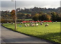
Sheep grazing on Sneedham's Green, Gloucester
Viewed across Sneedhams Road from the corner of Caledonian Road.
Image: © Jaggery
Taken: 22 Nov 2013
0.03 miles
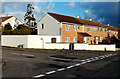
2
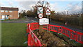
Red fencing around a City of Gloucester boundary sign
Temporary fencing was in place during roadworks in Winnycroft Lane in November 2013.
Image: © Jaggery
Taken: 22 Nov 2013
0.04 miles
3
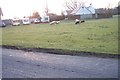
Sneedham's Green
Sneedham's Green is common land with sheep grazing. These sheep have no fences or animal grids to enclose them. Apparently the flock has learned where it is allowed to go.
Image: © Peter Kwan
Taken: 16 Feb 2003
0.05 miles
4
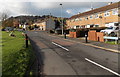
Sneedhams Road, Gloucester
On the left are a few of the dozens of sheep grazing http://www.geograph.org.uk/photo/3980201 on Sneedham's Green.
The right turn is for Caledonian Road. http://www.geograph.org.uk/photo/3980198
Image: © Jaggery
Taken: 22 Nov 2013
0.06 miles
5
Corner of Sneedhams Road and Bazeley Road, Gloucester
Sneedhams Road houses are on the right.
Image: © Jaggery
Taken: 22 Nov 2013
0.08 miles
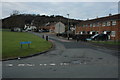
6
Sneedhams Green
An area of access land enclosing a trio of properties, at the foot of Robinswood Hill.
Image: © Derek Harper
Taken: 4 Jul 2008
0.08 miles
7
Houses at Matson
Houses at Matson with Robins Wood Hill in the background.
Image: © Philip Halling
Taken: 2 Jan 2011
0.09 miles
8
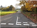
National Speed Limit south of Matson Lane, Gloucester
The 30mph speed limit along Matson Lane behind the camera increases to the National Speed Limit ahead, at the southern edge of the City of Gloucester.
Image: © Jaggery
Taken: 22 Nov 2013
0.10 miles
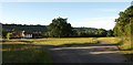
9
Towards Sneedham's Green, Matson
View from where Matson Lane turns sharp left. For a view in the opposite direction see http://www.geograph.org.uk/photo/115663
Image: © michael ely
Taken: 3 Sep 2010
0.10 miles
10
Sheep road sign, Matson, Gloucester
Located at the southern end of Matson Lane, on the corner of Sneedhams Road.
Dozens of sheep graze on the nearby green.
Image: © Jaggery
Taken: 22 Nov 2013
0.11 miles