IMAGES TAKEN NEAR TO
Matson Lane, GLOUCESTER, GL4 6DT
Introduction
This page details the photographs taken nearby to Matson Lane, GL4 6DT by members of the Geograph project.
The Geograph project started in 2005 with the aim of publishing, organising and preserving representative images for every square kilometre of Great Britain, Ireland and the Isle of Man.

There are currently over 7.5m images from over14,400 individuals and you can help contribute to the project by visiting https://www.geograph.org.uk
Image Map
Images are licensed for reuse under creativecommons.org/licenses/by-sa/2.0
Notes
- Clicking on the map will re-center to the selected point.
- The higher the marker number, the further away the image location is from the centre of the postcode.
Image Listing (40 Images Found)
Images are licensed for reuse under creativecommons.org/licenses/by-sa/2.0
Image
Details
Distance
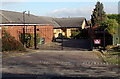
1
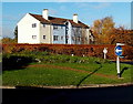
Houses on the corner of Matson Lane and Matson Avenue, Gloucester
Viewed across a roundabout.
Image: © Jaggery
Taken: 22 Nov 2013
0.01 miles
2
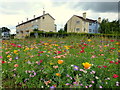
A bit of countryside in the city
This roundabout on Matson Lane has been sown with meadow flowering annuals and makes a great contrast with the angular lines of the social housing, and the approaching bus!
Image: © Jonathan Billinger
Taken: 5 Aug 2013
0.02 miles
3
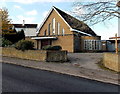
Catholic church, Matson Lane, Gloucester
The nameboard shows Roman Catholic Church of St Augustine of Canterbury.
Image: © Jaggery
Taken: 22 Nov 2013
0.02 miles
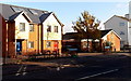
4
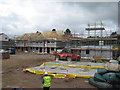
Development on site of The Musket, Matson
Image: © Alex McGregor
Taken: 13 Jun 2011
0.03 miles
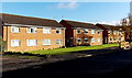
5
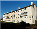
Norbury Avenue flats, Matson, Gloucester
4-storey block of flats viewed from the corner of Matson Lane.
Image: © Jaggery
Taken: 22 Nov 2013
0.04 miles
6
Houses near Matson Baptist Church, Gloucester
Viewed across Matson Avenue. Matson Baptist Church http://www.geograph.org.uk/photo/3965836 is on the right. On each side of the gap between houses and church, a street name sign shows CULVERIN CLOSE. Culverin is an unusual choice for a street name. It means either a kind of handgun, or a large cannon long in proportion to its bore.
As some nearby streets are named after birds, was culver (a dove or pigeon) intended?
Image: © Jaggery
Taken: 22 Nov 2013
0.06 miles
7
Matson Avenue houses, Gloucester
Viewed from the edge of the roundabout at the Matson Lane and Norbury Avenue crossroads.
Image: © Jaggery
Taken: 22 Nov 2013
0.06 miles
8
Painswick Road houses near Matson Lane, Gloucester
The Matson Lane junction is a few metres beyond the Belisha beacon on the right.
Image: © Jaggery
Taken: 22 Nov 2013
0.06 miles
9
Kingdom Hall entrance gates from Painswick Road, Gloucester
The entrance is at the edge of this http://www.geograph.org.uk/photo/3965783 Shell filling station. The Kingdom Hall, set back 40 metres from the gates, is a Jehovah's Witnesses place of worship.
Image: © Jaggery
Taken: 22 Nov 2013
0.06 miles
10
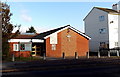
Matson Baptist Church, Gloucester
Viewed across Matson Avenue near the Rectory Road junction.
Image: © Jaggery
Taken: 22 Nov 2013
0.06 miles