IMAGES TAKEN NEAR TO
Langley Road, GLOUCESTER, GL4 6BA
Introduction
This page details the photographs taken nearby to Langley Road, GL4 6BA by members of the Geograph project.
The Geograph project started in 2005 with the aim of publishing, organising and preserving representative images for every square kilometre of Great Britain, Ireland and the Isle of Man.

There are currently over 7.5m images from over14,400 individuals and you can help contribute to the project by visiting https://www.geograph.org.uk
Image Map
Images are licensed for reuse under creativecommons.org/licenses/by-sa/2.0
Notes
- Clicking on the map will re-center to the selected point.
- The higher the marker number, the further away the image location is from the centre of the postcode.
Image Listing (4 Images Found)
Images are licensed for reuse under creativecommons.org/licenses/by-sa/2.0
Image
Details
Distance
1

Roadworks at the edge of Matson North, Gloucester
Viewed across the B4073 Painswick Road in late November 2013 looking
towards Norbury Avenue and Saintbridge Sports Centre. http://www.geograph.org.uk/photo/3965690
Image: © Jaggery
Taken: 22 Nov 2013
0.21 miles
2
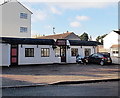
Heron Lodge Funeral Home, Gloucester
Painswick Road premises of Selim Smith & Co, funeral directors and memorial consultants.
Image: © Jaggery
Taken: 22 Nov 2013
0.22 miles
3

Saintbridge Sports Centre, Gloucester
Recently-built facility on the corner of Painswick Road and Norbury Avenue.
Image: © Jaggery
Taken: 22 Nov 2013
0.22 miles
4
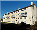
Norbury Avenue flats, Matson, Gloucester
4-storey block of flats viewed from the corner of Matson Lane.
Image: © Jaggery
Taken: 22 Nov 2013
0.24 miles