IMAGES TAKEN NEAR TO
Bishops Road, GLOUCESTER, GL4 5FP
Introduction
This page details the photographs taken nearby to Bishops Road, GL4 5FP by members of the Geograph project.
The Geograph project started in 2005 with the aim of publishing, organising and preserving representative images for every square kilometre of Great Britain, Ireland and the Isle of Man.

There are currently over 7.5m images from over14,400 individuals and you can help contribute to the project by visiting https://www.geograph.org.uk
Image Map
Images are licensed for reuse under creativecommons.org/licenses/by-sa/2.0
Notes
- Clicking on the map will re-center to the selected point.
- The higher the marker number, the further away the image location is from the centre of the postcode.
Image Listing (23 Images Found)
Images are licensed for reuse under creativecommons.org/licenses/by-sa/2.0
Image
Details
Distance
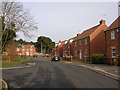
5
Fosse Close, Abbeymead
Bin day hereabouts is a Tuesday.
Image: © Jonathan Billinger
Taken: 27 Sep 2011
0.11 miles
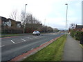
6
Gloucester : Hucclecote - Kimberland Way
A residential road.
Image: © Lewis Clarke
Taken: 2 Apr 2023
0.11 miles
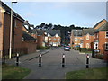
7
Gloucester : Matson - Bodenham Field
A residential road.
Image: © Lewis Clarke
Taken: 2 Apr 2023
0.13 miles
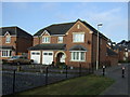
8
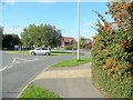
Abbeymead Avenue roundabout
A sunny morning in the housing estates of Gloucester.
Image: © Jonathan Billinger
Taken: 27 Sep 2011
0.13 miles
9
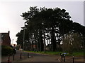
Gloucester, Abbeymead: Dancers Hill
Trees situated in Dancers Hill.
Image: © Alby
Taken: 24 Jan 2009
0.16 miles