IMAGES TAKEN NEAR TO
Wigmore Close, GLOUCESTER, GL4 5FF
Introduction
This page details the photographs taken nearby to Wigmore Close, GL4 5FF by members of the Geograph project.
The Geograph project started in 2005 with the aim of publishing, organising and preserving representative images for every square kilometre of Great Britain, Ireland and the Isle of Man.

There are currently over 7.5m images from over14,400 individuals and you can help contribute to the project by visiting https://www.geograph.org.uk
Image Map
Images are licensed for reuse under creativecommons.org/licenses/by-sa/2.0
Notes
- Clicking on the map will re-center to the selected point.
- The higher the marker number, the further away the image location is from the centre of the postcode.
Image Listing (25 Images Found)
Images are licensed for reuse under creativecommons.org/licenses/by-sa/2.0
Image
Details
Distance
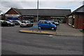
2
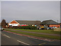
Gloucester, Abbeymead, Tesco Express
Tesco Express in Abbeymead behind The Turmut Hoer pub.
Image: © Alby
Taken: 24 Jan 2009
0.08 miles
3
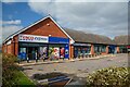
Gloucester : Matson - Tesco Express
A Tesco Express and other shops.
Image: © Lewis Clarke
Taken: 2 Apr 2023
0.08 miles
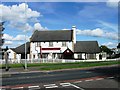
4
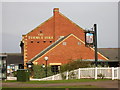
Gloucester, Abbeymead: The Turmut Hoer
The Turmut Hoer from the other side.
Image: © Alby
Taken: 24 Jan 2009
0.09 miles
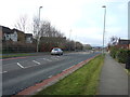
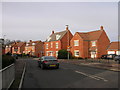
5
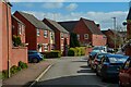
Gloucester : Matson - Bodenham Field
A residential road.
Image: © Lewis Clarke
Taken: 2 Apr 2023
0.10 miles
6
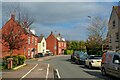
Gloucester : Hucclecote - Kimberland Way
A residential road.
Image: © Lewis Clarke
Taken: 2 Apr 2023
0.10 miles