IMAGES TAKEN NEAR TO
Coney Hill Road, GLOUCESTER, GL4 4NA
Introduction
This page details the photographs taken nearby to Coney Hill Road, GL4 4NA by members of the Geograph project.
The Geograph project started in 2005 with the aim of publishing, organising and preserving representative images for every square kilometre of Great Britain, Ireland and the Isle of Man.

There are currently over 7.5m images from over14,400 individuals and you can help contribute to the project by visiting https://www.geograph.org.uk
Image Map
Images are licensed for reuse under creativecommons.org/licenses/by-sa/2.0
Notes
- Clicking on the map will re-center to the selected point.
- The higher the marker number, the further away the image location is from the centre of the postcode.
Image Listing (21 Images Found)
Images are licensed for reuse under creativecommons.org/licenses/by-sa/2.0
Image
Details
Distance
1
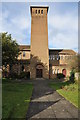
St Oswald's church, Coney Hill with St. Aldate
Looks like a post-WW2 estate church Italianate-style.
Image: © Jonathan Billinger
Taken: 30 Mar 2013
0.08 miles
5
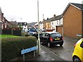
Hawthorn Avenue, Gloucester
Examples of a large council estate begun in 1931 by the City Architect, C.J. Scudamore.
Image: © Stephen Richards
Taken: 19 May 2015
0.13 miles
8
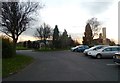
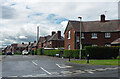
Car Park and Gloucester Crematorium
One area for parking is located north-east of the Crematorium (visible on right in image)
Image: © Clint Mann
Taken: 3 Dec 2014
0.15 miles