IMAGES TAKEN NEAR TO
Eastern Avenue, GLOUCESTER, GL4 4LJ
Introduction
This page details the photographs taken nearby to Eastern Avenue, GL4 4LJ by members of the Geograph project.
The Geograph project started in 2005 with the aim of publishing, organising and preserving representative images for every square kilometre of Great Britain, Ireland and the Isle of Man.

There are currently over 7.5m images from over14,400 individuals and you can help contribute to the project by visiting https://www.geograph.org.uk
Image Map
Images are licensed for reuse under creativecommons.org/licenses/by-sa/2.0
Notes
- Clicking on the map will re-center to the selected point.
- The higher the marker number, the further away the image location is from the centre of the postcode.
Image Listing (25 Images Found)
Images are licensed for reuse under creativecommons.org/licenses/by-sa/2.0
Image
Details
Distance
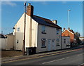
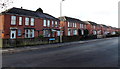
1
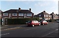
Chequers Road, Gloucester
Houses at the NW end of Chequers Road, viewed from the corner of Painswick Road.
Image: © Jaggery
Taken: 22 Nov 2013
0.12 miles
2
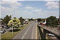
Eastern Avenue, A38, Gloucester
Looking towards the North from the pedestrian footbridge that crosses Eastern Avenue near to its junction with Coney Hill Road.
Image: © Colin Manton
Taken: 14 Jun 2011
0.13 miles
3
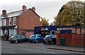
William Hill, Coney Hill Road, Gloucester
Betting shop at the western end of Coney Hill Road, near the A38 Eastern Avenue junction.
Image: © Jaggery
Taken: 22 Nov 2013
0.14 miles
4
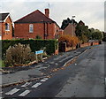
Old Painswick Road, Gloucester
Part of a boomerang-shaped section of the old road to Painswick,
on the east side of the straight course of the B4073 Painswick Road.
Image: © Jaggery
Taken: 22 Nov 2013
0.15 miles
5
Beechwood Funeral Services, Coney Hill, Gloucester
Located at 7A Highfield Place, near the entrance to Coney Hill Cemetery and Crematorium.
Image: © Jaggery
Taken: 22 Nov 2013
0.16 miles
6
Houses at the northern end of Painswick Road, Gloucester
The houses are opposite the Chequers Road junction.
Image: © Jaggery
Taken: 22 Nov 2013
0.16 miles
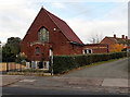
7
Chequers Bridge Community Centre, Gloucester
Viewed across Painswick Road.
Image: © Jaggery
Taken: 22 Nov 2013
0.17 miles
8
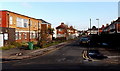
Savernake Road, Gloucester
Looking towards Malmesbury Road from Chequers Road.
Image: © Jaggery
Taken: 22 Nov 2013
0.19 miles
9
Painswick Road houses, Gloucester
The houses are NW of The Lampreys junction. http://www.geograph.org.uk/photo/3965535
Image: © Jaggery
Taken: 22 Nov 2013
0.19 miles
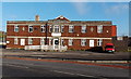
10
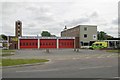
Gloucester Fire Station
Gloucester Fire Station, Eastern Avenue, Gloucester is station number W05 of Gloucestershire Fire & Rescue Service.
Image: © Kevin Hale
Taken: 28 May 2006
0.19 miles