IMAGES TAKEN NEAR TO
Rustic Close, GLOUCESTER, GL4 4FT
Introduction
This page details the photographs taken nearby to Rustic Close, GL4 4FT by members of the Geograph project.
The Geograph project started in 2005 with the aim of publishing, organising and preserving representative images for every square kilometre of Great Britain, Ireland and the Isle of Man.

There are currently over 7.5m images from over14,400 individuals and you can help contribute to the project by visiting https://www.geograph.org.uk
Image Map
Images are licensed for reuse under creativecommons.org/licenses/by-sa/2.0
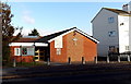
Notes
- Clicking on the map will re-center to the selected point.
- The higher the marker number, the further away the image location is from the centre of the postcode.
Image Listing (41 Images Found)
Images are licensed for reuse under creativecommons.org/licenses/by-sa/2.0
Image
Details
Distance
1
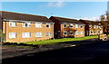
Painswick Road houses near Matson Lane, Gloucester
The Matson Lane junction is a few metres beyond the Belisha beacon on the right.
Image: © Jaggery
Taken: 22 Nov 2013
0.10 miles
2
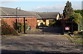
Kingdom Hall entrance gates from Painswick Road, Gloucester
The entrance is at the edge of this http://www.geograph.org.uk/photo/3965783 Shell filling station. The Kingdom Hall, set back 40 metres from the gates, is a Jehovah's Witnesses place of worship.
Image: © Jaggery
Taken: 22 Nov 2013
0.11 miles
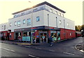
3
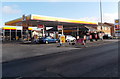
Shell, Painswick Road, Gloucester
Shell filling station, car wash and shop. Fuel prices per litre on display
in late November 2013 were 129.9 pence for unleaded petrol and 137.9 pence for diesel.
Image: © Jaggery
Taken: 22 Nov 2013
0.12 miles
4
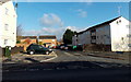
George Whitefield Close, Matson, Gloucester
Viewed across Matson Avenue.
Image: © Jaggery
Taken: 22 Nov 2013
0.13 miles
5
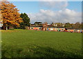
Bungalows and autumn colours, Matson, Gloucester
Viewed from Matson Avenue in late November 2013.
Image: © Jaggery
Taken: 22 Nov 2013
0.13 miles
6
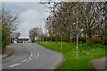
Gloucester : Matson - Painswick Road B4073
Looking along Painswick Road.
Image: © Lewis Clarke
Taken: 2 Apr 2023
0.13 miles
7
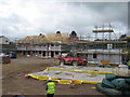
Development on site of The Musket, Matson
Image: © Alex McGregor
Taken: 13 Jun 2011
0.14 miles
8
Catholic church, Matson Lane, Gloucester
The nameboard shows Roman Catholic Church of St Augustine of Canterbury.
Image: © Jaggery
Taken: 22 Nov 2013
0.14 miles
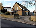
9
Matson Baptist Church, Gloucester
Viewed across Matson Avenue near the Rectory Road junction.
Image: © Jaggery
Taken: 22 Nov 2013
0.15 miles
10
Tesco Express, Painswick Road, Gloucester
This Tesco Express at 254 Painswick Road is open every day from 6am to 11pm.
Image: © Jaggery
Taken: 22 Nov 2013
0.15 miles