IMAGES TAKEN NEAR TO
Barnett Way, GLOUCESTER, GL4 3QA
Introduction
This page details the photographs taken nearby to Barnett Way, GL4 3QA by members of the Geograph project.
The Geograph project started in 2005 with the aim of publishing, organising and preserving representative images for every square kilometre of Great Britain, Ireland and the Isle of Man.

There are currently over 7.5m images from over14,400 individuals and you can help contribute to the project by visiting https://www.geograph.org.uk
Image Map
Images are licensed for reuse under creativecommons.org/licenses/by-sa/2.0
Notes
- Clicking on the map will re-center to the selected point.
- The higher the marker number, the further away the image location is from the centre of the postcode.
Image Listing (37 Images Found)
Images are licensed for reuse under creativecommons.org/licenses/by-sa/2.0
Image
Details
Distance
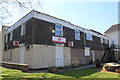
1
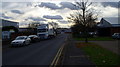
Barnet Way
A business park in Barnwood Gloucester
Image: © David Robinson
Taken: 20 Nov 2008
0.03 miles
2
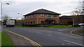
Faraday House, Barnet Way
Typical purpose built office block on the business park.
Image: © David Robinson
Taken: 20 Nov 2008
0.03 miles
3
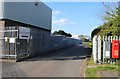
Entrance to Wall's Sports Club, Hammond Way, Barnwood
Image: © Richard Auckland
Taken: 18 Apr 2015
0.05 miles
4
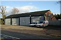
Gloucester old fire station
Gloucester old fire station, Barnwood Road, Gloucester. It would appear from the building pattern to be the old AFS (Auxiliary Fire Service) fire station.
Image: © Kevin Hale
Taken: 21 Jan 2007
0.09 miles
5
Post Office - Wotton Hall Barnwood Road
This is the latest location for Barnwood's Post Office.
Image: © Richard Auckland
Taken: 18 Apr 2015
0.11 miles
6
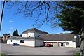
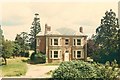
The rear of the Wotton Hall Club, Barnwood Road
This is taken from the car park at the rear of the building. The original house can be seen surrounded by the various extensions added over the years.
Image: © Richard Auckland
Taken: 18 Apr 2015
0.11 miles
7
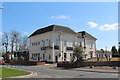
Wotton Hall Club Barnwood Road
Originally a private residence this building was bought for use as a working men's club in about 1935 and subsequently extended.
Image: © Richard Auckland
Taken: 18 Apr 2015
0.11 miles
8
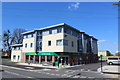
Barnwood Road new Morrisons Store
This store, opened spring 2015, stands on the site of what was Barnwood's AFS fire station. The building later became a general storeage facility and finally that of Barnwood Builders.
Domestic accommodation occupies the upper floors of this building
Image: © Richard Auckland
Taken: 18 Apr 2015
0.11 miles
9
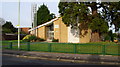
Church of Latter Day Saints, Barnwood
Modern building with a good car park.
This church is on the site of a building called Lynthorpe, which was at some time a residence for patients at the nearby Barnwood House Hospital mental asylum.
Image: © David Robinson
Taken: 28 Nov 2008
0.11 miles
10
Lynthorpe, Barnwood Road
This building was used by the nearby Barnwood House Mental Hospital for housing patients.
The Church of Latter Day Saints is now on this site
Image: © Family of Fay Fisher
Taken: Unknown
0.12 miles