IMAGES TAKEN NEAR TO
Naas Lane, GLOUCESTER, GL4 0XA
Introduction
This page details the photographs taken nearby to Naas Lane, GL4 0XA by members of the Geograph project.
The Geograph project started in 2005 with the aim of publishing, organising and preserving representative images for every square kilometre of Great Britain, Ireland and the Isle of Man.

There are currently over 7.5m images from over14,400 individuals and you can help contribute to the project by visiting https://www.geograph.org.uk
Image Map
Images are licensed for reuse under creativecommons.org/licenses/by-sa/2.0
Notes
- Clicking on the map will re-center to the selected point.
- The higher the marker number, the further away the image location is from the centre of the postcode.
Image Listing (3 Images Found)
Images are licensed for reuse under creativecommons.org/licenses/by-sa/2.0
Image
Details
Distance
1
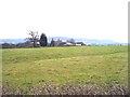
Chambers Farm near Brookthorpe
Looking south towards the farm across a field with an interesting holloway running from left to right.
Image: © Bob Embleton
Taken: 13 Mar 2006
0.09 miles
2
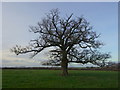
Specimen oak
In a field north of Chambers Farm on Naas Lane.
Image: © Jonathan Billinger
Taken: 7 Feb 2014
0.13 miles
3
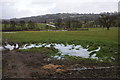
Farmland near Harescombe
Farmland below the Cotswold escarpment to the north of Harescombe.
Image: © Philip Halling
Taken: 26 Jan 2013
0.24 miles